IMAGES TAKEN NEAR TO
Church Lane, IPSWICH, IP7 5LY
Introduction
This page details the photographs taken nearby to Church Lane, IP7 5LY by members of the Geograph project.
The Geograph project started in 2005 with the aim of publishing, organising and preserving representative images for every square kilometre of Great Britain, Ireland and the Isle of Man.

There are currently over 7.5m images from over14,400 individuals and you can help contribute to the project by visiting https://www.geograph.org.uk
Image Map
Images are licensed for reuse under creativecommons.org/licenses/by-sa/2.0
Notes
- Clicking on the map will re-center to the selected point.
- The higher the marker number, the further away the image location is from the centre of the postcode.
Image Listing (30 Images Found)
Images are licensed for reuse under creativecommons.org/licenses/by-sa/2.0
Image
Details
Distance
1
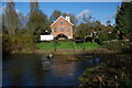
Layham Ford
This is the site of the former ford between Upper and Lower Layham. It is found at Layham Mill on private property.
Image: © John Walton
Taken: 8 Nov 2012
0.04 miles
2
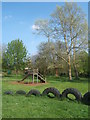
Recreation ground at Upper Layham
In an attractive setting near the River Brett with some nice trees.
Image: © Andrew Hill
Taken: 21 Apr 2009
0.09 miles
3
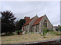
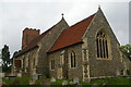
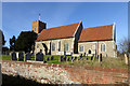
Layham St Andrew?s church
The church serves both Upper and Lower Layham. The roofline is low pitched and the red brick tower has no great height. A scratch dial has been re-positioned low down on the east side of the nave buttress during restoration in the 1860s. Inside the church, the lovely traditional style 13th century hexagonal purbeck marble font is standing on a modern base, supported by six marble columns around a central shaft. In the chancel, the 19th century reredos is a fine piece of the stonemason’s art, with tiled niches, crocketted pinnacles and colourful paintings. In the south west wall of the nave there is a dole shelf, which was once used to hand out bread to the poor.
Image: © Adrian S Pye
Taken: 6 Aug 2007
0.11 miles
4
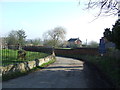
Dead End
Dead end road at Lower Layham, Suffolk.
Image: © Keith Evans
Taken: 17 Feb 2013
0.12 miles
6
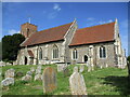
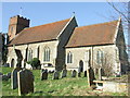
St. Andrew's Church, Layham
The tower dates from 1742. The remainder dates from about 1300 but much renewed in 1861 https://historicengland.org.uk/listing/the-list/list-entry/1037136?section=official-list-entry
Image: © Jonathan Thacker
Taken: 14 May 2022
0.12 miles
7
Church of St Andrew
https://historicengland.org.uk/listing/the-list/list-entry/1037136?section=official-list-entry
Image: © Sandy Gerrard
Taken: 25 Oct 2024
0.13 miles
8
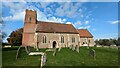
Layham church
St. Andrew's is a grade II listed building with a replacement brick tower of 1742.
Image: © Robin Webster
Taken: 19 Nov 2017
0.13 miles
9
Layham church
St. Andrew's is a grade II listed building with a replacement brick tower of 1742.
Image: © Robin Webster
Taken: 19 Nov 2017
0.13 miles
10
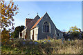
St Andrew Lower Layham
The church of St Andrew Lower Layham, Suffolk for more info on the church see http://www.suffolkchurches.co.uk/layham.htm
Image: © Keith Evans
Taken: 17 Feb 2013
0.13 miles