IMAGES TAKEN NEAR TO
Tayler Close, IPSWICH, IP7 5HJ
Introduction
This page details the photographs taken nearby to Tayler Close, IP7 5HJ by members of the Geograph project.
The Geograph project started in 2005 with the aim of publishing, organising and preserving representative images for every square kilometre of Great Britain, Ireland and the Isle of Man.

There are currently over 7.5m images from over14,400 individuals and you can help contribute to the project by visiting https://www.geograph.org.uk
Image Map
Images are licensed for reuse under creativecommons.org/licenses/by-sa/2.0
Notes
- Clicking on the map will re-center to the selected point.
- The higher the marker number, the further away the image location is from the centre of the postcode.
Image Listing (108 Images Found)
Images are licensed for reuse under creativecommons.org/licenses/by-sa/2.0
Image
Details
Distance
1
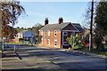
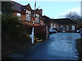
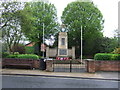
Cross Farm House, Hadleigh
On Station Road.
Image: © Robin Webster
Taken: 19 Nov 2017
0.04 miles
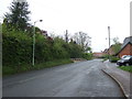
4
End of Hadleigh Railway Walk
The end on Station Road, with the site of the station to the right. There is a small car park here.
Image: © Robin Webster
Taken: 19 Nov 2017
0.08 miles
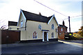
6
Edge Hall, High Street, Hadleigh
A grade II listed hotel, timber framed, refaced with 18th century red brick.
Image: © Robin Webster
Taken: 19 Nov 2017
0.11 miles
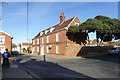
7
A corner house, Hadleigh
On the corner of Station Road and Benton Street, this early 19th century house is grade II listed.
Image: © Robin Webster
Taken: 19 Nov 2017
0.11 miles
8
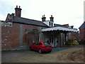
Former Hadleigh Station
Hadleigh railway station was opened in 1847 and closed to passenger traffic in 1932, with freight services lasting on until 1965 now a rather swanky home
Image: © Oxyman
Taken: 5 Jan 2011
0.12 miles
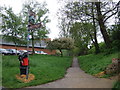
10
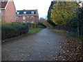
Railway Walk
This footpath is on the former route of a railway
Image: © Oxyman
Taken: 13 Nov 2007
0.12 miles