IMAGES TAKEN NEAR TO
George Street, IPSWICH, IP7 5BD
Introduction
This page details the photographs taken nearby to George Street, IP7 5BD by members of the Geograph project.
The Geograph project started in 2005 with the aim of publishing, organising and preserving representative images for every square kilometre of Great Britain, Ireland and the Isle of Man.

There are currently over 7.5m images from over14,400 individuals and you can help contribute to the project by visiting https://www.geograph.org.uk
Image Map
Images are licensed for reuse under creativecommons.org/licenses/by-sa/2.0
Notes
- Clicking on the map will re-center to the selected point.
- The higher the marker number, the further away the image location is from the centre of the postcode.
Image Listing (156 Images Found)
Images are licensed for reuse under creativecommons.org/licenses/by-sa/2.0
Image
Details
Distance
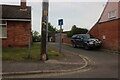
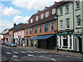
1
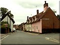
Old houses in George Street
The road off to the right is Threadneedle Street and off to the left is Stonehouse Road.
Image: © Robert Edwards
Taken: 11 Jun 2008
0.07 miles
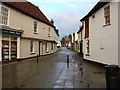
3
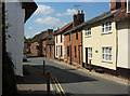
George Street, Hadleigh
Looking towards the town centre.
Image: © Andrew Hill
Taken: 11 Aug 2009
0.08 miles
5
Spooners Lane, Hadleigh
From Angel Street
Image: © David Howard
Taken: 22 May 2022
0.08 miles
7
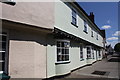
3 and 5 George Street, Hadleigh
15th to 16th century Grade II Listed building.
Image: © Jo and Steve Turner
Taken: 17 Jun 2017
0.10 miles
8
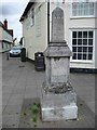
Obelisk milestone, High Street, Hadleigh
Carved stone post by the B1070, in parish of Hadleigh (Babergh District), High Street, by No. 55 at junction with George Street, on paved area. Erected by the Hadleigh Turnpike Trust in the 19th century.
Inscription reads:-
: XIIII / MILES / TO / COLCH / ESTER : : XX / MILES / TO / BURY : : X / MILES / TO / LAVEN / DEN (?HAM?) : : X / TO / IPSWICH : : 64 / MILES / TO / LONDON :
Grade II listed. List Entry Number: 1036738
https://historicengland.org.uk/listing/the-list/list-entry/1036738
Milestone Society National ID: SU_HDLE.
Image: © Milestone Society
Taken: 7 Jul 2017
0.11 miles
9

Junction of High Street and George Street, Hadleigh
This end of George Street is pedestrianized. An elaborate milestone gives 64 miles to London, but Roman numbers for other places, such as XX miles to Bury. It is a grade II listed 'building', probably 18th century, and is listed as being on the other side of the High Street on the corner of Church Street, roughly where the camera is. It must have been moved to a safer location when George Street was blocked to vehicles. The 64 miles was probably measured from Aldgate Pump, the old datum for distances into Essex and beyond.
Image: © Robin Webster
Taken: 19 Nov 2017
0.11 miles
10
Hadleigh High Street
Looking north from the end of Church Street. So far the town has resisted the pressures from the major supermarkets to open in Hadleigh, so the High Street has a variety of traditional shops.
Image: © Andrew Hill
Taken: 11 Aug 2009
0.11 miles