IMAGES TAKEN NEAR TO
Cranworth Road, IPSWICH, IP7 5BA
Introduction
This page details the photographs taken nearby to Cranworth Road, IP7 5BA by members of the Geograph project.
The Geograph project started in 2005 with the aim of publishing, organising and preserving representative images for every square kilometre of Great Britain, Ireland and the Isle of Man.

There are currently over 7.5m images from over14,400 individuals and you can help contribute to the project by visiting https://www.geograph.org.uk
Image Map
Images are licensed for reuse under creativecommons.org/licenses/by-sa/2.0
Notes
- Clicking on the map will re-center to the selected point.
- The higher the marker number, the further away the image location is from the centre of the postcode.
Image Listing (32 Images Found)
Images are licensed for reuse under creativecommons.org/licenses/by-sa/2.0
Image
Details
Distance
2
Steps at end of Cranworth Road, Hadleigh
Not signposted, and not too clear on maps, I was relieved to find there was indeed a way up the old railway embankment to the Hadleigh Railway Walk along the top.
Image: © Robin Webster
Taken: 19 Nov 2017
0.08 miles
3
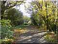
Hadleigh Railway Walk
A path along the former Hadleigh branch line from Bentley, which closed to passengers in 1932 and freight in 1965.
Image: © Robin Webster
Taken: 19 Nov 2017
0.10 miles
6
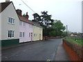
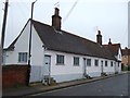
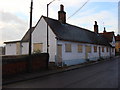
Raven Almshouses, Benton Street, Hadleigh (Suffolk)
The almshouses date from c.1636 and were founded by the eponymous John Raven.
Image: © David Kemp
Taken: 11 May 2019
0.10 miles
8
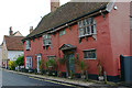
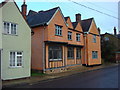
92-94 Benton Street, Hadleigh (Suffolk)
The left-hand house is described in Pevsner's guide as having "a richly decorated C17 front with oriels on carved brackets, carved eaves brackets, and some decayed pargetting". The pair are apparently known as 'The Flying Chariot'.
Image: © David Kemp
Taken: 11 May 2019
0.13 miles
9
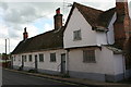
The Old Monkey
This building has sections that date to the 15th century. It was a pub for over 400 years, known officially as The Kings Arms, but referred to still today as "The Old Monkey". It is now a private residence and Bed and Breakfast
http://www.theoldmonkey.co.uk/
Image: © Oxyman
Taken: 13 Nov 2007
0.13 miles
10
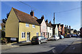
Older houses, Benton Street, Hadleigh
Grade II listed buildings, probably 17th century timber framed with modern red brick fronts, according to the 1972 listing description. If that is indeed the case, the bricks are well disguised now.
Image: © Robin Webster
Taken: 19 Nov 2017
0.13 miles