IMAGES TAKEN NEAR TO
Benton Street, IPSWICH, IP7 5AR
Introduction
This page details the photographs taken nearby to Benton Street, IP7 5AR by members of the Geograph project.
The Geograph project started in 2005 with the aim of publishing, organising and preserving representative images for every square kilometre of Great Britain, Ireland and the Isle of Man.

There are currently over 7.5m images from over14,400 individuals and you can help contribute to the project by visiting https://www.geograph.org.uk
Image Map
Images are licensed for reuse under creativecommons.org/licenses/by-sa/2.0
Notes
- Clicking on the map will re-center to the selected point.
- The higher the marker number, the further away the image location is from the centre of the postcode.
Image Listing (71 Images Found)
Images are licensed for reuse under creativecommons.org/licenses/by-sa/2.0
Image
Details
Distance
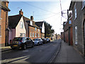
1
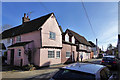
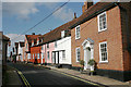
Older houses, Benton Street, Hadleigh
Grade II listed buildings, probably 16th century with later alterations.
Image: © Robin Webster
Taken: 19 Nov 2017
0.04 miles
3
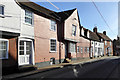
Older houses, Benton Street, Hadleigh
Grade II listed buildings, probably 17th century with alterations.
Image: © Robin Webster
Taken: 19 Nov 2017
0.05 miles
4
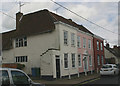
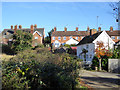
77-81 Benton Street, Hadleigh (Suffolk)
These houses probably date from the C16 but their external features are largely C17-C18 according to the Historic England website.
Image: © David Kemp
Taken: 11 May 2019
0.06 miles
5
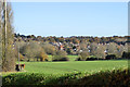
View north-east over valley of River Brett
Looking towards Benton Street, Hadleigh and more recent housing beyond.
Image: © Robin Webster
Taken: 19 Nov 2017
0.07 miles
6
Picturesque houses in Benton Street, Hadleigh (Suffolk)
Image: © David Kemp
Taken: 11 May 2019
0.07 miles
8
Tinkers Lane up to Benton Street, Hadleigh
Now just a footpath link across a footbridge from the part of Tinkers Lane on the other side of the river, but formerly a through vehicle route via a ford. The only fit vehicles were probably horse and carts, though. Tinkers Cottage is on the right. The lane reaches Benton Street through the gap in the houses.
Image: © Robin Webster
Taken: 19 Nov 2017
0.08 miles
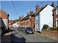
9
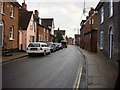
Benton Street, Hadleigh
A street with several grade II listed buildings, houses back to the 17th century, as the group here.
Image: © Robin Webster
Taken: 19 Nov 2017
0.08 miles
10
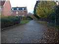
Railway Walk
This footpath is on the former route of a railway
Image: © Oxyman
Taken: 13 Nov 2007
0.08 miles