IMAGES TAKEN NEAR TO
Stone Street, IPSWICH, IP6 9SY
Introduction
This page details the photographs taken nearby to Stone Street, IP6 9SY by members of the Geograph project.
The Geograph project started in 2005 with the aim of publishing, organising and preserving representative images for every square kilometre of Great Britain, Ireland and the Isle of Man.

There are currently over 7.5m images from over14,400 individuals and you can help contribute to the project by visiting https://www.geograph.org.uk
Image Map
Images are licensed for reuse under creativecommons.org/licenses/by-sa/2.0
Notes
- Clicking on the map will re-center to the selected point.
- The higher the marker number, the further away the image location is from the centre of the postcode.
Image Listing (13 Images Found)
Images are licensed for reuse under creativecommons.org/licenses/by-sa/2.0
Image
Details
Distance
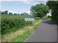
1
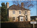
House at Marywood Farm, Stone Street, Crowfield
Image: © Andrew Hill
Taken: 30 Jan 2008
0.01 miles
3
Stone Street & the footpath to Spring Lane
Image: © Geographer
Taken: 5 Jun 2011
0.04 miles
5
Stone Street following Course of Roman Road Through Crowfield
Image: © Bikeboy
Taken: 6 Jun 2012
0.12 miles
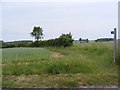
6
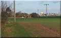
Farmland near Crowfield, east of Stone Street
Looking to the water tower in TM1557.
Image: © Andrew Hill
Taken: 30 Jan 2008
0.19 miles
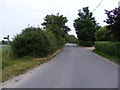
7
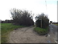
Entrance to Clay Cottage
Off Stone Street
Image: © Geographer
Taken: 25 Mar 2016
0.22 miles
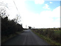
8

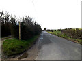
Stone Street, Crowfield
At the entrance to Clay Cottage
Image: © Geographer
Taken: 25 Mar 2016
0.22 miles
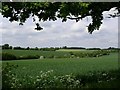
9
Stone Street, Crowfield
Near Clay Cottage
Image: © Geographer
Taken: 25 Mar 2016
0.22 miles
10
Stone Street, Crowfield
At the entrance to Clay Cottage
Image: © Geographer
Taken: 25 Mar 2016
0.22 miles