IMAGES TAKEN NEAR TO
Ipswich Road, IPSWICH, IP6 9HT
Introduction
This page details the photographs taken nearby to Ipswich Road, IP6 9HT by members of the Geograph project.
The Geograph project started in 2005 with the aim of publishing, organising and preserving representative images for every square kilometre of Great Britain, Ireland and the Isle of Man.

There are currently over 7.5m images from over14,400 individuals and you can help contribute to the project by visiting https://www.geograph.org.uk
Image Map
Images are licensed for reuse under creativecommons.org/licenses/by-sa/2.0
Notes
- Clicking on the map will re-center to the selected point.
- The higher the marker number, the further away the image location is from the centre of the postcode.
Image Listing (35 Images Found)
Images are licensed for reuse under creativecommons.org/licenses/by-sa/2.0
Image
Details
Distance
1
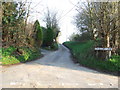
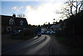
Strugglers Lane
Strugglers Lane Witnesham, Suffolk.
Image: © Keith Evans
Taken: 11 Mar 2012
0.04 miles
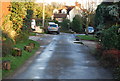
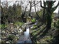
2
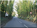
Entering Witnesham
Entering Witnesham, Suffolk.
Image: © Keith Evans
Taken: 11 Mar 2012
0.04 miles
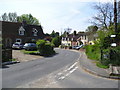
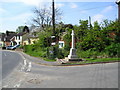
10
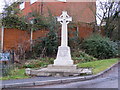
Witnesham War Memorial
On the B1077 The Street at the junction with Hall Lane
Image: © Geographer
Taken: 19 Jan 2009
0.17 miles