IMAGES TAKEN NEAR TO
Tuddenham, IPSWICH, IP6 9EE
Introduction
This page details the photographs taken nearby to IP6 9EE by members of the Geograph project.
The Geograph project started in 2005 with the aim of publishing, organising and preserving representative images for every square kilometre of Great Britain, Ireland and the Isle of Man.

There are currently over 7.5m images from over14,400 individuals and you can help contribute to the project by visiting https://www.geograph.org.uk
Image Map
Images are licensed for reuse under creativecommons.org/licenses/by-sa/2.0
Notes
- Clicking on the map will re-center to the selected point.
- The higher the marker number, the further away the image location is from the centre of the postcode.
Image Listing (7 Images Found)
Images are licensed for reuse under creativecommons.org/licenses/by-sa/2.0
Image
Details
Distance
1
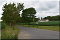
Avenue, driveway and farmworker's bungalow, Maple Tree Farm
Looking west from Clopton Road. The poultry houses of the farm are hidden by the belt of trees behind the bungalow.
Image: © Simon Mortimer
Taken: 26 May 2019
0.02 miles
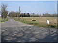
4

Pond (or reservoir) opposite Maple Tree farm
Image: © Oxymoron
Taken: 21 Mar 2009
0.17 miles
5
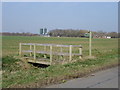
Footpath bridge
With the silos at Maple Tree farm visible in the distance.
Image: © Oxymoron
Taken: 21 Mar 2009
0.21 miles
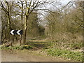
6
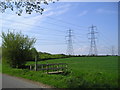
Footpath bridge and pylons
Bridge on the footpath between Grundisburgh and Witnesham. The National Grid pylons march across the countryside from Sizewell.
Image: © Chris Holifield
Taken: 26 Apr 2009
0.22 miles
7
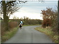
Horse Riders And Country Lane
Two horse riders along a country lane near to Witnesham Suffolk.
Image: © Keith Evans
Taken: 28 Jan 2007
0.24 miles