IMAGES TAKEN NEAR TO
Culpho, IPSWICH, IP6 9EA
Introduction
This page details the photographs taken nearby to IP6 9EA by members of the Geograph project.
The Geograph project started in 2005 with the aim of publishing, organising and preserving representative images for every square kilometre of Great Britain, Ireland and the Isle of Man.

There are currently over 7.5m images from over14,400 individuals and you can help contribute to the project by visiting https://www.geograph.org.uk
Image Map
Images are licensed for reuse under creativecommons.org/licenses/by-sa/2.0
Notes
- Clicking on the map will re-center to the selected point.
- The higher the marker number, the further away the image location is from the centre of the postcode.
Image Listing (22 Images Found)
Images are licensed for reuse under creativecommons.org/licenses/by-sa/2.0
Image
Details
Distance
1
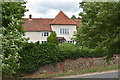
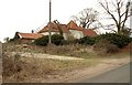
Culpho Hall
Culpho Hall is an early 17th Century manor house and a Grade II Listed Building.
Image: © Simon Mortimer
Taken: 21 Jun 2020
0.01 miles
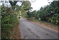
5
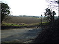
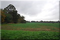
Footpath Crossing
Footpath crossing country road near to Culpho, Suffolk.
Image: © Keith Evans
Taken: 11 Mar 2012
0.09 miles
10
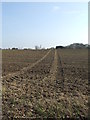
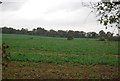
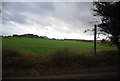
Marked Footpath
Footpath across a field near to Playford, Suffolk.
Image: © Keith Evans
Taken: 11 Mar 2012
0.14 miles