IMAGES TAKEN NEAR TO
Hill Farm Road, IPSWICH, IP6 9DU
Introduction
This page details the photographs taken nearby to Hill Farm Road, IP6 9DU by members of the Geograph project.
The Geograph project started in 2005 with the aim of publishing, organising and preserving representative images for every square kilometre of Great Britain, Ireland and the Isle of Man.

There are currently over 7.5m images from over14,400 individuals and you can help contribute to the project by visiting https://www.geograph.org.uk
Image Map
Images are licensed for reuse under creativecommons.org/licenses/by-sa/2.0
Notes
- Clicking on the map will re-center to the selected point.
- The higher the marker number, the further away the image location is from the centre of the postcode.
Image Listing (110 Images Found)
Images are licensed for reuse under creativecommons.org/licenses/by-sa/2.0
Image
Details
Distance
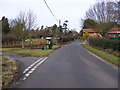
1
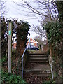
Footpath to Church Lane
Off Hill Farm Road
Image: © Geographer
Taken: 12 Jan 2012
0.01 miles
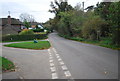
2
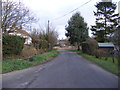
Hill Farm Road, Playford
At the junction with The Street
Image: © Geographer
Taken: 12 Jan 2012
0.03 miles
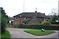
3
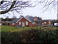
Playford Village Hall
Off The Street near the junction with Brook Lane
Image: © Geographer
Taken: 24 Jan 2009
0.03 miles
5
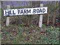
Hill Farm Road sign
At the junction with The Street
Image: © Geographer
Taken: 12 Jan 2012
0.03 miles
6
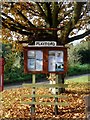
Playford, notice board
The bench is carved EIIR 1977 for the Queen's silver jubilee.
Image: © Bikeboy
Taken: 29 Oct 2015
0.03 miles
7
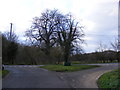
Hill Farm Road, Playford
At the junction with The Street
Image: © Geographer
Taken: 12 Jan 2012
0.03 miles
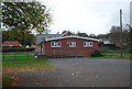
10
The Street, Playford & The Street Postbox
At the junction with Brook Lane near Playford Village Hall
Postbox No.IP6 1199
Image: © Geographer
Taken: 24 Jan 2009
0.05 miles