IMAGES TAKEN NEAR TO
Westerfield Road, IPSWICH, IP6 9AG
Introduction
This page details the photographs taken nearby to Westerfield Road, IP6 9AG by members of the Geograph project.
The Geograph project started in 2005 with the aim of publishing, organising and preserving representative images for every square kilometre of Great Britain, Ireland and the Isle of Man.

There are currently over 7.5m images from over14,400 individuals and you can help contribute to the project by visiting https://www.geograph.org.uk
Image Map
Images are licensed for reuse under creativecommons.org/licenses/by-sa/2.0
Notes
- Clicking on the map will re-center to the selected point.
- The higher the marker number, the further away the image location is from the centre of the postcode.
Image Listing (122 Images Found)
Images are licensed for reuse under creativecommons.org/licenses/by-sa/2.0
Image
Details
Distance
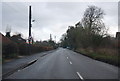
2
B1077 Westerfield Road
Looking towards Westerfield Railway Station at the crossroads with Church Lane & Lower Road
Image: © Geographer
Taken: 19 Jan 2009
0.03 miles
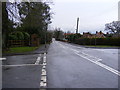
4

Westerfield Road at the junction of Lower Road
Image: © David Howard
Taken: 22 May 2022
0.04 miles
5

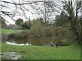
Pond behind Westerfield village hall
Image: © Chris Holifield
Taken: 11 Jun 2021
0.04 miles

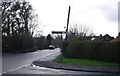
9
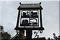
Westerfield village sign
The sign, constructed of steel, is divided into four quarters, showing a swan, the church, a house, and a steam engine.
The swan recalls a public house. The original Swan Inn was sold in 1829 and the present Swan, on the opposite side of the road, opened its doors a year or two later. The church of Saint Mary Magdalene, just a short distance from the sign is the oldest building in the village. The building lower left I am unable to identify. If anybody can fill in the blank I would be most appreciative.
The train recalls the coming of the railway and the Great Eastern Railway Company. Westerfield station is one stop before Ipswich on the upline.
Image: © Adrian S Pye
Taken: 22 Oct 2020
0.06 miles
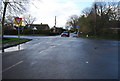
10
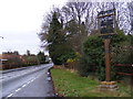
B1077 Westerfield Road & Westerfield Village Sign
At the junction with Church Lane
Image: © Geographer
Taken: 19 Jan 2009
0.06 miles