IMAGES TAKEN NEAR TO
Baylham, IPSWICH, IP6 8RE
Introduction
This page details the photographs taken nearby to IP6 8RE by members of the Geograph project.
The Geograph project started in 2005 with the aim of publishing, organising and preserving representative images for every square kilometre of Great Britain, Ireland and the Isle of Man.

There are currently over 7.5m images from over14,400 individuals and you can help contribute to the project by visiting https://www.geograph.org.uk
Image Map
Images are licensed for reuse under creativecommons.org/licenses/by-sa/2.0
Notes
- Clicking on the map will re-center to the selected point.
- The higher the marker number, the further away the image location is from the centre of the postcode.
Image Listing (5 Images Found)
Images are licensed for reuse under creativecommons.org/licenses/by-sa/2.0
Image
Details
Distance
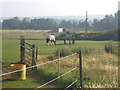
1
Private track at Baylham
This tarmac track leads to a pit owned by Lafarge Aggregates.
Image: © Bob Jones
Taken: 1 Aug 2006
0.07 miles
2
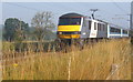
Train bound for Ipswich
Seen on an early morning walk before the heat of the day.
Image: © Andrew Hill
Taken: 27 Jul 2008
0.21 miles
3
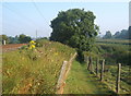
Footpath beside railway line
The path switches from railway to riverbank. The river was lost in a sea of nettles beyond the tree when I walked this way.
Image: © Andrew Hill
Taken: 27 Jul 2008
0.22 miles
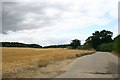
4
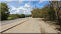
Lay-by on B1113 South of Needham Market
Image: © Sandy Gerrard
Taken: 23 Apr 2023
0.24 miles