IMAGES TAKEN NEAR TO
Darmsden, IPSWICH, IP6 8RB
Introduction
This page details the photographs taken nearby to IP6 8RB by members of the Geograph project.
The Geograph project started in 2005 with the aim of publishing, organising and preserving representative images for every square kilometre of Great Britain, Ireland and the Isle of Man.

There are currently over 7.5m images from over14,400 individuals and you can help contribute to the project by visiting https://www.geograph.org.uk
Image Map
Images are licensed for reuse under creativecommons.org/licenses/by-sa/2.0
Notes
- Clicking on the map will re-center to the selected point.
- The higher the marker number, the further away the image location is from the centre of the postcode.
Image Listing (9 Images Found)
Images are licensed for reuse under creativecommons.org/licenses/by-sa/2.0
Image
Details
Distance
1
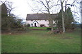
Priestley, a property in a truly quiet location
Image: © Andrew Hill
Taken: 9 Jan 2008
0.02 miles
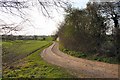
2
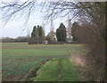
View back to Priestley from track to Tarston Hall
Image: © Andrew Hill
Taken: 9 Jan 2008
0.06 miles
3
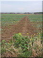
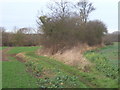
Muddy track across the fields towards Needham Market
Image: © Andrew Hill
Taken: 9 Jan 2008
0.15 miles
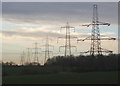
6

Blue skies and pylons
Pylons near to Barking, Suffolk.
Image: © Keith Evans
Taken: 22 Aug 2010
0.22 miles
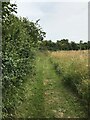
7
Footpath to Priestley Wood
This track, also a public footpath, starts at the end of the private road that runs through the estate village of Darmsden.
Image: © Bob Jones
Taken: 11 Apr 2007
0.22 miles
8
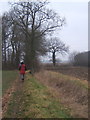
Footpath towards Swingen's Wood
Deep in quiet Suffolk countryside.
Image: © Andrew Hill
Taken: 1 Jan 2009
0.24 miles