IMAGES TAKEN NEAR TO
Fen Lane, IPSWICH, IP6 8QD
Introduction
This page details the photographs taken nearby to Fen Lane, IP6 8QD by members of the Geograph project.
The Geograph project started in 2005 with the aim of publishing, organising and preserving representative images for every square kilometre of Great Britain, Ireland and the Isle of Man.

There are currently over 7.5m images from over14,400 individuals and you can help contribute to the project by visiting https://www.geograph.org.uk
Image Map
Images are licensed for reuse under creativecommons.org/licenses/by-sa/2.0
Notes
- Clicking on the map will re-center to the selected point.
- The higher the marker number, the further away the image location is from the centre of the postcode.
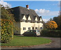
Image Listing (15 Images Found)
Images are licensed for reuse under creativecommons.org/licenses/by-sa/2.0
Image
Details
Distance


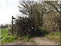
7
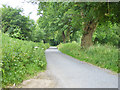
Fen Lane
The fens are down to the right along the valley floor.
Image: © Robin Webster
Taken: 17 Jun 2017
0.11 miles
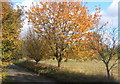
8
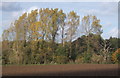
Field and line of trees off Low lane near Creeting St Mary
Low Lane named on OS 1:25,000 map.
Image: © Andrew Hill
Taken: 29 Oct 2007
0.19 miles
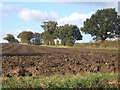
9
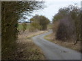
Looking along Low Lane
A no through lane for traffic between Earl Stonham and Creeting St Mary.
Image: © Andrew Hill
Taken: 9 Mar 2010
0.21 miles