IMAGES TAKEN NEAR TO
All Saints Road, IPSWICH, IP6 8PL
Introduction
This page details the photographs taken nearby to All Saints Road, IP6 8PL by members of the Geograph project.
The Geograph project started in 2005 with the aim of publishing, organising and preserving representative images for every square kilometre of Great Britain, Ireland and the Isle of Man.

There are currently over 7.5m images from over14,400 individuals and you can help contribute to the project by visiting https://www.geograph.org.uk
Image Map
Images are licensed for reuse under creativecommons.org/licenses/by-sa/2.0
Notes
- Clicking on the map will re-center to the selected point.
- The higher the marker number, the further away the image location is from the centre of the postcode.
Image Listing (5 Images Found)
Images are licensed for reuse under creativecommons.org/licenses/by-sa/2.0
Image
Details
Distance
1
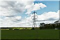
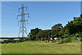
Earl Stonham: Electricity transmission lines
Image: © Michael Garlick
Taken: 30 Apr 2021
0.22 miles
2
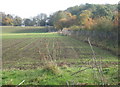
Field and woodland edge near Earl Stonham
Image: © Andrew Hill
Taken: 29 Oct 2007
0.23 miles
3
Tractors parked on a field edge
Looking north from All Saints' Road, Creeting St. Mary.
Image: © Simon Mortimer
Taken: 16 Jul 2021
0.24 miles