IMAGES TAKEN NEAR TO
The Tye, IPSWICH, IP6 8JD
Introduction
This page details the photographs taken nearby to The Tye, IP6 8JD by members of the Geograph project.
The Geograph project started in 2005 with the aim of publishing, organising and preserving representative images for every square kilometre of Great Britain, Ireland and the Isle of Man.

There are currently over 7.5m images from over14,400 individuals and you can help contribute to the project by visiting https://www.geograph.org.uk
Image Map
Images are licensed for reuse under creativecommons.org/licenses/by-sa/2.0
Notes
- Clicking on the map will re-center to the selected point.
- The higher the marker number, the further away the image location is from the centre of the postcode.
Image Listing (5 Images Found)
Images are licensed for reuse under creativecommons.org/licenses/by-sa/2.0
Image
Details
Distance
1
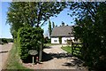
Top Farm, Barking Tye
This farmhouse is set back off the B1078 road at Barking Tye.
Image: © Bob Jones
Taken: 1 May 2007
0.09 miles
2

Old Hay Rake
Old hay rake near to Barking, Suffolk.
Image: © Keith Evans
Taken: 21 Aug 2011
0.12 miles
3

Clear Footpath Sign
Clear footpath sign near to Barking, Suffolk.
Image: © Keith Evans
Taken: 21 Aug 2011
0.13 miles
4

Baling Machine
Baler near Lower Farm Barking, Suffolk.
Image: © Keith Evans
Taken: 21 Aug 2011
0.15 miles
5
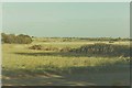
The tye from Tye Barn House in 1983
The road is the B1078
Image: © John Baker
Taken: Unknown
0.21 miles