IMAGES TAKEN NEAR TO
Barking Road, IPSWICH, IP6 8HG
Introduction
This page details the photographs taken nearby to Barking Road, IP6 8HG by members of the Geograph project.
The Geograph project started in 2005 with the aim of publishing, organising and preserving representative images for every square kilometre of Great Britain, Ireland and the Isle of Man.

There are currently over 7.5m images from over14,400 individuals and you can help contribute to the project by visiting https://www.geograph.org.uk
Image Map
Images are licensed for reuse under creativecommons.org/licenses/by-sa/2.0
Notes
- Clicking on the map will re-center to the selected point.
- The higher the marker number, the further away the image location is from the centre of the postcode.
Image Listing (16 Images Found)
Images are licensed for reuse under creativecommons.org/licenses/by-sa/2.0
Image
Details
Distance
1

B1078 north of Kennels Farm
The smaller scale O/S maps don't show the s on Kennels.
Image: © Stuart Logan
Taken: 28 Jun 2013
0.05 miles
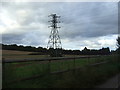
3

Pylon and cables crossing B1078 south-west of Needham Market
Image: © David Smith
Taken: 19 Jun 2014
0.07 miles
4
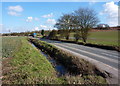
B1078 towards Barking
The road from Needham Market passes through open fields.
Image: © Andrew Hill
Taken: 2 Mar 2010
0.10 miles
5

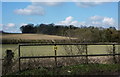
Fields and line of pylons
Gently rising fields north of the B1078, less than 1 km from the edge of Needham Market.
Image: © Andrew Hill
Taken: 2 Mar 2010
0.12 miles
6
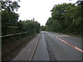
B1078 towards Needham Market
Heading north east.
Image: © JThomas
Taken: 14 Sep 2015
0.14 miles
7

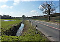
Flooded field below Oak Hill
Seen from the road between Needham Market and Barking.
Image: © Andrew Hill
Taken: 2 Mar 2010
0.14 miles
8
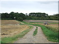
To Titley Hill
Track leading to Titley Hill near to Needham Market.
Image: © Keith Evans
Taken: 22 Aug 2010
0.15 miles
9
B1078 towards Needham Market
Seen from the start of the private farm track to Park Wood.
Image: © Andrew Hill
Taken: 2 Mar 2010
0.15 miles
10
Fields by the B1078
Looking towards Spriteshall Grove. The road here is just half a kilometre southwest of the edge of Needham Market.
Image: © Andrew Hill
Taken: 2 Mar 2010
0.15 miles