IMAGES TAKEN NEAR TO
Constitution Hill, IPSWICH, IP6 8AH
Introduction
This page details the photographs taken nearby to Constitution Hill, IP6 8AH by members of the Geograph project.
The Geograph project started in 2005 with the aim of publishing, organising and preserving representative images for every square kilometre of Great Britain, Ireland and the Isle of Man.

There are currently over 7.5m images from over14,400 individuals and you can help contribute to the project by visiting https://www.geograph.org.uk
Image Map
Images are licensed for reuse under creativecommons.org/licenses/by-sa/2.0
Notes
- Clicking on the map will re-center to the selected point.
- The higher the marker number, the further away the image location is from the centre of the postcode.
Image Listing (221 Images Found)
Images are licensed for reuse under creativecommons.org/licenses/by-sa/2.0
Image
Details
Distance
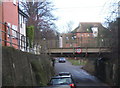
1
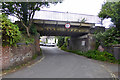
Railway bridge on Bridge Street, Needham Market
The main line to Norwich from Liverpool Street crosses.
Image: © Robin Webster
Taken: 17 Jun 2017
0.02 miles
2
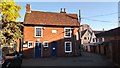
National School Board Building
The former 19th century market town school building is now home to several local small businesses.
Image: © Stuart Shepherd
Taken: 26 Sep 2018
0.05 miles
4

River Gipping, Needham Market
Looking upstream, with the mill stream from Hawks Mill joining from the left. To the right was the route taken by the Ipswich and Stowmarket Navigation, closed in the 1930s, although it was disused here long before that.
Image: © Robin Webster
Taken: 17 Jun 2017
0.05 miles
5
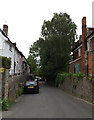
Lane between the High Street and King William Street, Needham Market
The church of St. John the Baptist on the left. The house facing the camera is fargment of a larger sixteenth century building https://historicengland.org.uk/listing/the-list/list-entry/1253683?section=official-listing
Image: © Jonathan Thacker
Taken: 3 Aug 2021
0.05 miles
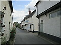
6
Cottages on a back street
King William Street, Needham Market.
Image: © Andrew Hill
Taken: 5 Sep 2007
0.06 miles
7
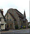
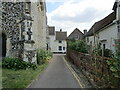
Saint John the Baptist Church
On the B1113 High Street at the junction with King William Street
http://www.needhammarketparishchurch.org/
Image: © Geographer
Taken: 2 Jun 2015
0.06 miles
8
Low railway bridge, Hawks Mill Street, Needham Market
Image: © Andrew Hill
Taken: 9 Jan 2008
0.06 miles
9
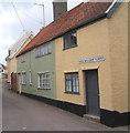
Bridge Street, Needham Market
The fish and chip shop https://historicengland.org.uk/listing/the-list/list-entry/1232023?section=official-listing on the right and the adjacent buildings date from the sixteenth century.
Image: © Jonathan Thacker
Taken: 3 Aug 2021
0.06 miles
10
King William Street, Needham Market
At the junction with Hawks Mill Street
Image: © Geographer
Taken: 30 Apr 2016
0.06 miles