IMAGES TAKEN NEAR TO
Ashbocking Road, IPSWICH, IP6 0SE
Introduction
This page details the photographs taken nearby to Ashbocking Road, IP6 0SE by members of the Geograph project.
The Geograph project started in 2005 with the aim of publishing, organising and preserving representative images for every square kilometre of Great Britain, Ireland and the Isle of Man.

There are currently over 7.5m images from over14,400 individuals and you can help contribute to the project by visiting https://www.geograph.org.uk
Image Map
Images are licensed for reuse under creativecommons.org/licenses/by-sa/2.0
Notes
- Clicking on the map will re-center to the selected point.
- The higher the marker number, the further away the image location is from the centre of the postcode.
Image Listing (56 Images Found)
Images are licensed for reuse under creativecommons.org/licenses/by-sa/2.0
Image
Details
Distance
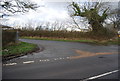
7
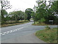
Road Junction
Road junction near to Hemingstone, Suffolk as seen from the entrance of Potters Farm.
Image: © Keith Evans
Taken: 13 Sep 2009
0.04 miles
8
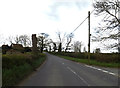
Ashbocking Road, Hemingstone
At the junction with Clay Lane
Image: © Geographer
Taken: 26 Apr 2016
0.05 miles
9

Hemingstone Village Name sign on Clay Lane
At the junction with Ashbocking Road
Image: © Geographer
Taken: 26 Apr 2016
0.05 miles