IMAGES TAKEN NEAR TO
Pond End, IPSWICH, IP6 0QZ
Introduction
This page details the photographs taken nearby to Pond End, IP6 0QZ by members of the Geograph project.
The Geograph project started in 2005 with the aim of publishing, organising and preserving representative images for every square kilometre of Great Britain, Ireland and the Isle of Man.

There are currently over 7.5m images from over14,400 individuals and you can help contribute to the project by visiting https://www.geograph.org.uk
Image Map
Images are licensed for reuse under creativecommons.org/licenses/by-sa/2.0
Notes
- Clicking on the map will re-center to the selected point.
- The higher the marker number, the further away the image location is from the centre of the postcode.
Image Listing (144 Images Found)
Images are licensed for reuse under creativecommons.org/licenses/by-sa/2.0
Image
Details
Distance
1
Footpath And Hydrant Signs
Footpath and fir hydrant signs Henley, Suffolk.
Image: © Keith Evans
Taken: 22 Feb 2009
0.01 miles
5
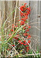
Little shrub with lots of berries
By a fence alongside Ashbocking Road, Henley.
Image: © Andrew Hill
Taken: 16 Sep 2008
0.04 miles
7
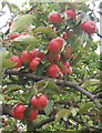
Apples overhanging the road near Henley school
Image: © Andrew Hill
Taken: 16 Sep 2008
0.09 miles
8
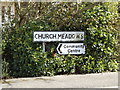
Church Meadows sign
On Church Meadows at the junction with Ashbocking Road
Image: © Geographer
Taken: 17 Apr 2016
0.10 miles
9
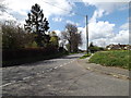
Ashbocking Road, Henley
At the junction with Church Meadows
Image: © Geographer
Taken: 17 Apr 2016
0.10 miles
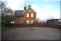
10
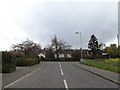
Church Meadow, Henley
At the junction with Ashbocking Road near Henley Community Centre
Image: © Geographer
Taken: 26 Apr 2016
0.10 miles