IMAGES TAKEN NEAR TO
St. Peters Avenue, IPSWICH, IP6 0HY
Introduction
This page details the photographs taken nearby to St. Peters Avenue, IP6 0HY by members of the Geograph project.
The Geograph project started in 2005 with the aim of publishing, organising and preserving representative images for every square kilometre of Great Britain, Ireland and the Isle of Man.

There are currently over 7.5m images from over14,400 individuals and you can help contribute to the project by visiting https://www.geograph.org.uk
Image Map
Images are licensed for reuse under creativecommons.org/licenses/by-sa/2.0
Notes
- Clicking on the map will re-center to the selected point.
- The higher the marker number, the further away the image location is from the centre of the postcode.
Image Listing (162 Images Found)
Images are licensed for reuse under creativecommons.org/licenses/by-sa/2.0
Image
Details
Distance
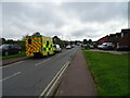
3
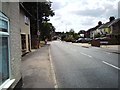
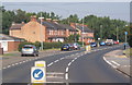
Norwich Road, Claydon
To the north of Claydon High Street, looking back towards the village. This road was formerly the main A45 road from Ipswich to Norwich and Cambridge. A lot quieter now!
Image: © Tim Marchant
Taken: 5 Jul 2010
0.07 miles
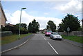
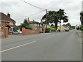
5
Norwich Road, Claydon
National Cycle Route 51.
Image: © JThomas
Taken: 12 May 2023
0.08 miles
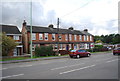
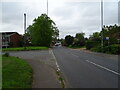
8
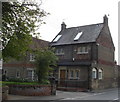
Terraced houses, Gipping Road, Claydon
The bridge carrying the A14 can just be seen in the trees on the extreme right.
Image: © Andrew Hill
Taken: 27 Jul 2008
0.10 miles