IMAGES TAKEN NEAR TO
The Circle, IPSWICH, IP6 0FE
Introduction
This page details the photographs taken nearby to The Circle, IP6 0FE by members of the Geograph project.
The Geograph project started in 2005 with the aim of publishing, organising and preserving representative images for every square kilometre of Great Britain, Ireland and the Isle of Man.

There are currently over 7.5m images from over14,400 individuals and you can help contribute to the project by visiting https://www.geograph.org.uk
Image Map
Images are licensed for reuse under creativecommons.org/licenses/by-sa/2.0
Notes
- Clicking on the map will re-center to the selected point.
- The higher the marker number, the further away the image location is from the centre of the postcode.
Image Listing (20 Images Found)
Images are licensed for reuse under creativecommons.org/licenses/by-sa/2.0
Image
Details
Distance
1
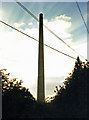
Mason's Cement Works Stack, Great Blakenham
This landmark has recently been demolished. It was 120 m high and was built in 1966. For more details, see http://www.cementkilns.co.uk/cement_kiln_masons.html.
Image: © Dylan Moore
Taken: 14 Sep 1996
0.02 miles
2
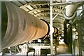
No5 Kiln: Mason's Cement Works, Great Blakenham
I notice from Google Maps that this site has now been cleared so I thought I'd dig out a few old photos. This cement plant commenced operation in 1913. Kiln 5 commenced operation in 1966: it was 500 ft (152 m) in length, 14'6" (4.42 m) in diameter, and produced around 1100 tonnes of Portland cement clinker per day, using the "wet process". The plant ceased operation in 1999. For more details, see [http://www.cementkilns.co.uk/cement_kiln_masons.html].
Image: © Dylan Moore
Taken: 14 Sep 1996
0.04 miles
3
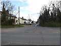
Chapel Lane, Great Blakenham
At the junction with the B1113 Bramford Road
Image: © Geographer
Taken: 30 Apr 2016
0.08 miles
4
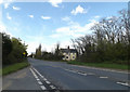
B1113 Bramford Road, Great Blakenham
Looking towards the junction with Chapel Lane at the junction with Addison Way
Image: © Geographer
Taken: 30 Apr 2016
0.08 miles
5
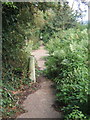
Footpath near Great Blakenham
The path seems little used and overgrown. This is probably for a variety of reasons. The B roads are poorly served with paths, there is an industrial estate alongside and a large working quarry nearby.
Image: © Andrew Hill
Taken: 21 Aug 2008
0.08 miles

7
B1113 Bramford Road, Great Blakenham
At the junction with Addison Way
Image: © Geographer
Taken: 30 Apr 2016
0.10 miles
8

Slurry Tank: Mason's Cement Works, Great Blakenham
This plant used the "wet process" in which the raw materials were ground together with water to produce a slurry with approximately the consistency of paint. The slurry was then fed to the kiln which successively dried, calcined and sintered it at 1400°C to form Portland cement clinker. The raw materials here were Upper Chalk and Boulder Clay from quarries in Image The slurry contained around 32% of water by mass: this had to be evaporated, at significant energy-cost. Because of this, wet process plants have been progressively phased out over the last thirty years. There are currently (2008) only three wet-process cement kilns left in operation in the British Isles. For more details, see http://www.cementkilns.co.uk/cement_kiln_masons.html.
2009 Update: there are now no wet process kilns left: the last one (Westbury Kiln 2 Image) shut down in 2009.
Image: © Dylan Moore
Taken: 14 Sep 1996
0.12 miles
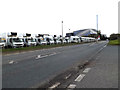
9
Industrial units seen from the River Gipping
Image: © N Chadwick
Taken: 18 Sep 2011
0.14 miles
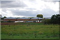
10
Industrial and trading area, Great Blakenham
Image: © Andrew Hill
Taken: 21 Aug 2008
0.17 miles