IMAGES TAKEN NEAR TO
Hereford Drive, IPSWICH, IP6 0BF
Introduction
This page details the photographs taken nearby to Hereford Drive, IP6 0BF by members of the Geograph project.
The Geograph project started in 2005 with the aim of publishing, organising and preserving representative images for every square kilometre of Great Britain, Ireland and the Isle of Man.

There are currently over 7.5m images from over14,400 individuals and you can help contribute to the project by visiting https://www.geograph.org.uk
Image Map
Images are licensed for reuse under creativecommons.org/licenses/by-sa/2.0
Notes
- Clicking on the map will re-center to the selected point.
- The higher the marker number, the further away the image location is from the centre of the postcode.
Image Listing (33 Images Found)
Images are licensed for reuse under creativecommons.org/licenses/by-sa/2.0
Image
Details
Distance
2
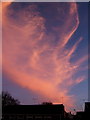
Spectacular evening sky, Claydon, looking SSE
At almost the same time there was a breathtaking orange sunset to the west.
Image: © Andrew Hill
Taken: 27 Jan 2008
0.07 miles
3
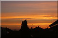
Sunset sky, looking west
At almost the same time there was a spectacular cloud formation lit in pinkish colours to the SSE.
Image: © Andrew Hill
Taken: 27 Jan 2008
0.08 miles