IMAGES TAKEN NEAR TO
Old Ipswich Road, IPSWICH, IP6 0AB
Introduction
This page details the photographs taken nearby to Old Ipswich Road, IP6 0AB by members of the Geograph project.
The Geograph project started in 2005 with the aim of publishing, organising and preserving representative images for every square kilometre of Great Britain, Ireland and the Isle of Man.

There are currently over 7.5m images from over14,400 individuals and you can help contribute to the project by visiting https://www.geograph.org.uk
Image Map
Images are licensed for reuse under creativecommons.org/licenses/by-sa/2.0
Notes
- Clicking on the map will re-center to the selected point.
- The higher the marker number, the further away the image location is from the centre of the postcode.
Image Listing (115 Images Found)
Images are licensed for reuse under creativecommons.org/licenses/by-sa/2.0
Image
Details
Distance
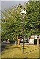
1
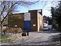
Claydon Telephone Exchange
On Old Ipswich Road
Image: © Geographer
Taken: 8 Apr 2009
0.01 miles
2
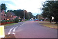
Old Ipswich Rd
The former A14, pre bypass.
Image: © N Chadwick
Taken: 22 Sep 2012
0.02 miles
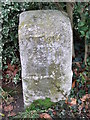
3
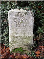
Old Milestone by the former A45, Claydon Parish
Carved stone post by the UC road (was A45), in parish of CLAYDON (MID SUFFOLK District), Claydon, by the road, on West side of road. Erected by the Claydon, Blakenham, Brockford & Stowmarket turnpike trust in the 19th century.
Inscription reads:-
: TO / STOW / MARKET / 8 M. : : TO / BURY / 22 M. :
Milestone Society National ID: SU_SMIW08.
Image: © R Mudhar & D Riseborough
Taken: 12 Dec 2010
0.02 miles
4
Old Ipswich Rd
The original course of the A14 before the bypass was built.
Image: © N Chadwick
Taken: 22 Sep 2012
0.04 miles
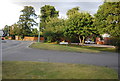
5
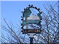
Claydon Village Sign
On Old Ipswich Road
(Close up)
Image: © Geographer
Taken: 8 Apr 2009
0.04 miles
8
To Bury 22
Old milepost Claydon, Suffolk on what was the old A45 / A140. For overall view see http://www.geograph.org.uk/photo/1168470 For more info see http://milestones.megalithia.com/sites/tm132496.htm do look at their home page.
Image: © Keith Evans
Taken: 18 Feb 2009
0.04 miles
10
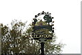
Claydon village sign
The sign consists of five main elements and trees and flowers on an arched trellis. Quite pretty when freshly painted I would guess. The village hall features large, standing on a bridge over the River Gipping. Beneath the bridge is an old plough and a sheaf of corn representing Claydon of days gone by. The whole sign is supported by an anvil representing the industrial past.
Image: © Adrian S Pye
Taken: 24 Oct 2020
0.05 miles