
IMAGES TAKEN NEAR TO
Main Road, IPSWICH, IP5 2PD
Introduction
This page details the photographs taken nearby to Main Road, IP5 2PD by members of the Geograph project.
The Geograph project started in 2005 with the aim of publishing, organising and preserving representative images for every square kilometre of Great Britain, Ireland and the Isle of Man.

There are currently over 7.5m images from over14,400 individuals and you can help contribute to the project by visiting https://www.geograph.org.uk
Image Map
Images are licensed for reuse under creativecommons.org/licenses/by-sa/2.0
Notes
- Clicking on the map will re-center to the selected point.
- The higher the marker number, the further away the image location is from the centre of the postcode.
Image Listing (42 Images Found)
Images are licensed for reuse under creativecommons.org/licenses/by-sa/2.0
Image
Details
Distance

2

Ashdale Road, Kesgrave
At the junction with the A1214 Main Road
Image: © Geographer
Taken: 14 Mar 2014
0.03 miles
3
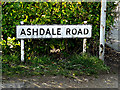
Ashdale Road sign
On Ashdale Road at the junction with the A1214 Main Road
Image: © Geographer
Taken: 14 Mar 2014
0.04 miles
4

A1214 approaches junction with Ropes Drive
Image: © Stuart Logan
Taken: 23 Jun 2013
0.13 miles
5

Kesgrave - St. Francis of Assisi mural
This fascinating mural was painted at some point during the 1940's, believed to be by American military personnel lodging at Kesgrave Hall. I first came across this in 1984 as this little building which was sinking in to the mud was just inside the entrance to Sinks Pit (now Hales) on the left-hand side. When I last visited it was still there and I took this picture.
Image: © Nick Mutton 01329 000000
Taken: 23 Jun 2005
0.13 miles
6

St Michael & the Holy Family, Kesgrave, from north
This modern Roman Catholic church, was built initially as a memorial chapel for Michael Rope, aeronautical engineer, who died in the crash of the R101 airship. It has been twice extended and now serves Catholics from a wide area. See also http://www.suffolkchurches.co.uk/kesghf.htm
Image: © Zorba the Geek
Taken: 20 Aug 2008
0.14 miles
7
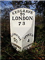
Replica Milepost by the A1214, Kesgrave High School
Cast iron milepost by the A1214, in parish of KESGRAVE (SUFFOLK COASTAL District), Kesgrave High School, by the road. Ipswich iron casting (replacement), erected by the Ipswich to South Town, & Darsham to Bungay turnpike trust in the 20th century.
Inscription reads:-
: YARMOUTH / 50 / WOODBRIDGE / 3 : : KESGRAVE / TO / LONDON / 73 : : IPSWICH / 4 / COLCHESTER / 22 :
Suffolk HER.
HER Number (Pref. Ref.): PLY 039 https://www.heritagegateway.org.uk/Gateway/Results_Single.aspx?uid=MSF22479&resourceID=1017
Milestone Society National ID: SU_LI73R.
Image: © R Mudhar & D Riseborough
Taken: 12 Dec 2010
0.14 miles
8

St Michael & the Holy Family, Kesgrave, from south
The other side from Image, this view shows the small hedged graveyard, containing family graves of the family largely responsible for the church's foundation and development. See also http://www.suffolkchurches.co.uk/kesghf.htm
Image: © Zorba the Geek
Taken: 20 Aug 2008
0.14 miles
9

Mural at Sinks Pit
This is an earlier one I took in 1986
Image: © Nick Mutton 01329 000000
Taken: 22 Feb 1986
0.14 miles
10

St.Michael's Catholic Church, Kesgrave Notice Board
Off the A1214 Main Road near the junction with Ropes Drive
Image: © Geographer
Taken: 24 Jan 2009
0.14 miles