IMAGES TAKEN NEAR TO
The Fairways, IPSWICH, IP4 5TN
Introduction
This page details the photographs taken nearby to The Fairways, IP4 5TN by members of the Geograph project.
The Geograph project started in 2005 with the aim of publishing, organising and preserving representative images for every square kilometre of Great Britain, Ireland and the Isle of Man.

There are currently over 7.5m images from over14,400 individuals and you can help contribute to the project by visiting https://www.geograph.org.uk
Image Map
Images are licensed for reuse under creativecommons.org/licenses/by-sa/2.0
Notes
- Clicking on the map will re-center to the selected point.
- The higher the marker number, the further away the image location is from the centre of the postcode.
Image Listing (25 Images Found)
Images are licensed for reuse under creativecommons.org/licenses/by-sa/2.0
Image
Details
Distance
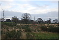
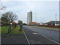
1
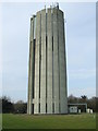
Rushmere Water Tower
Water tower Rushmere St.Andrew, Suffolk. A Mouchel design build in the 1970s for more info see http://www.freston.net/stuff/ip-rushmeretower.html
Image: © Keith Evans
Taken: 29 Jan 2009
0.14 miles
4
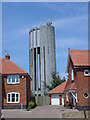
Water Tower
This water tower is among the houses in an estate just east of Ipswich.
Image: © steve
Taken: 10 Jul 2005
0.19 miles
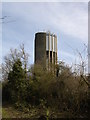

8
Rushmere Water Tower
Water tower Rushmere St.Andrew, Suffolk. A Mouchel design build in the 1970s for more info see http://www.freston.net/stuff/ip-rushmeretower.html
Image: © Keith Evans
Taken: 29 Jan 2009
0.19 miles