IMAGES TAKEN NEAR TO
Gleneagles Drive, IPSWICH, IP4 5SE
Introduction
This page details the photographs taken nearby to Gleneagles Drive, IP4 5SE by members of the Geograph project.
The Geograph project started in 2005 with the aim of publishing, organising and preserving representative images for every square kilometre of Great Britain, Ireland and the Isle of Man.

There are currently over 7.5m images from over14,400 individuals and you can help contribute to the project by visiting https://www.geograph.org.uk
Image Map
Images are licensed for reuse under creativecommons.org/licenses/by-sa/2.0
Notes
- Clicking on the map will re-center to the selected point.
- The higher the marker number, the further away the image location is from the centre of the postcode.
Image Listing (33 Images Found)
Images are licensed for reuse under creativecommons.org/licenses/by-sa/2.0
Image
Details
Distance
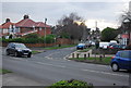
1
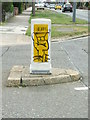
Graffiti On Bollard
Graffiti on traffic bollard Ipswich, Suffolk.
Image: © Keith Evans
Taken: 13 May 2009
0.11 miles
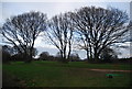
5
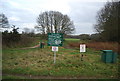
Start of the Sandlings Walk, Rushmere Common
Image: © N Chadwick
Taken: 18 Jan 2014
0.13 miles
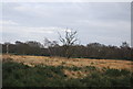
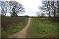
9
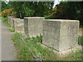
Anti Tank Blocks
Concrete anti tank blocking Rushmere Heath Heath Road Ipswich, Suffolk. For other view see http://www.geograph.org.uk/photo/1301807
Image: © Keith Evans
Taken: 13 May 2009
0.17 miles
10
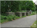
Anti Tank Blocks
Concrete anti tank blocking Rushmere Heath Heath Road Ipswich, Suffolk. For other view see http://www.geograph.org.uk/photo/1301814
Image: © Keith Evans
Taken: 13 May 2009
0.17 miles