IMAGES TAKEN NEAR TO
Britannia Road, IPSWICH, IP4 5HE
Introduction
This page details the photographs taken nearby to Britannia Road, IP4 5HE by members of the Geograph project.
The Geograph project started in 2005 with the aim of publishing, organising and preserving representative images for every square kilometre of Great Britain, Ireland and the Isle of Man.

There are currently over 7.5m images from over14,400 individuals and you can help contribute to the project by visiting https://www.geograph.org.uk
Image Map
Images are licensed for reuse under creativecommons.org/licenses/by-sa/2.0
Notes
- Clicking on the map will re-center to the selected point.
- The higher the marker number, the further away the image location is from the centre of the postcode.
Image Listing (56 Images Found)
Images are licensed for reuse under creativecommons.org/licenses/by-sa/2.0
Image
Details
Distance
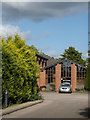
1
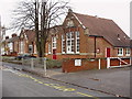
Britannia Road Primary School
A primary school in the east of Ipswich for children from 4-11.
Image: © steve
Taken: Unknown
0.04 miles
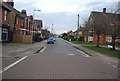
4
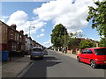
Britannia Road, Ipswich
Near St.Andrews Church
Image: © Geographer
Taken: 8 Jun 2015
0.08 miles
5
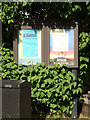
St Andrew's Church Notice Board
Off Britannia Road at the entrance to St Andrew's Church
Image: © Geographer
Taken: 8 Jun 2015
0.08 miles
6
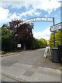
Entrance to St.Andrews Church
Off Britannia Road
Image: © Geographer
Taken: 8 Jun 2015
0.08 miles
7
Entrance to St Andrew's Church
Off Britannia Road
Image: © Geographer
Taken: 8 Jun 2015
0.08 miles
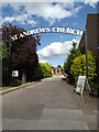
8
St Andrew's Church, Ipswich
Off Britannia Road
Image: © Geographer
Taken: 8 Jun 2015
0.09 miles
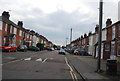
10
Freehold Rd
The route of NCN route 1 through Ipswich.
Image: © N Chadwick
Taken: 18 Jan 2014
0.10 miles