IMAGES TAKEN NEAR TO
Humber Doucy Lane, IPSWICH, IP4 3NU
Introduction
This page details the photographs taken nearby to Humber Doucy Lane, IP4 3NU by members of the Geograph project.
The Geograph project started in 2005 with the aim of publishing, organising and preserving representative images for every square kilometre of Great Britain, Ireland and the Isle of Man.

There are currently over 7.5m images from over14,400 individuals and you can help contribute to the project by visiting https://www.geograph.org.uk
Image Map
Images are licensed for reuse under creativecommons.org/licenses/by-sa/2.0
Notes
- Clicking on the map will re-center to the selected point.
- The higher the marker number, the further away the image location is from the centre of the postcode.
Image Listing (81 Images Found)
Images are licensed for reuse under creativecommons.org/licenses/by-sa/2.0
Image
Details
Distance
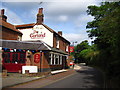
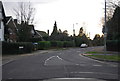
2
The Garland Public House
On Humber Doucy lane
Image: © Geographer
Taken: 14 Apr 2012
0.04 miles
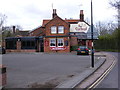
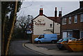
3
Humber Doucy Lane & The Garland Public House
Image: © Geographer
Taken: 14 Apr 2012
0.04 miles
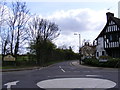
5
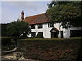
Humber Doucy House
This is a grade II listed building. See the Historic England listing at: https://www.historicengland.org.uk/listing/the-list/list-entry/1037706
Image: © Steven Fosdick
Taken: 10 Sep 2017
0.05 miles
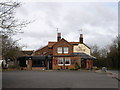
6
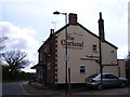
The Garland Public House
On Humber Doucy Lane
Image: © Geographer
Taken: 14 Apr 2012
0.06 miles
7
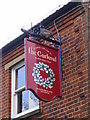
The Garland Public House sign
On Humber Doucy Lane
Image: © Geographer
Taken: 14 Apr 2012
0.06 miles
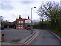
10
Humber Doucy Lane, Rushmere St.Andrew
At the junction with Rushmere Street & Road
Image: © Geographer
Taken: 14 Apr 2012
0.08 miles