IMAGES TAKEN NEAR TO
Sidegate Lane West, IPSWICH, IP4 3DJ
Introduction
This page details the photographs taken nearby to Sidegate Lane West, IP4 3DJ by members of the Geograph project.
The Geograph project started in 2005 with the aim of publishing, organising and preserving representative images for every square kilometre of Great Britain, Ireland and the Isle of Man.

There are currently over 7.5m images from over14,400 individuals and you can help contribute to the project by visiting https://www.geograph.org.uk
Image Map
Images are licensed for reuse under creativecommons.org/licenses/by-sa/2.0
Notes
- Clicking on the map will re-center to the selected point.
- The higher the marker number, the further away the image location is from the centre of the postcode.
Image Listing (56 Images Found)
Images are licensed for reuse under creativecommons.org/licenses/by-sa/2.0
Image
Details
Distance

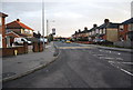
4
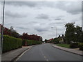
Sidegate Lane West, Westerfield
At the junction with Alma Close
Image: © Geographer
Taken: 1 Jun 2015
0.09 miles
7
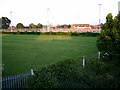
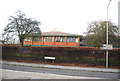
Sports facility beside Tuddenham Road, Ipswich
Image: © John Goldsmith
Taken: 16 Jun 2009
0.11 miles
8
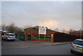
Sidegate Lane, Westerfield
At the junction with Sidegate Lane West & Sidegate Lane
Image: © Geographer
Taken: 1 Jun 2015
0.11 miles
9
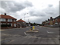
Sidegate Lane, Westerfield
At the junction with Sidegate Lane & Sidegate Lane West
Image: © Geographer
Taken: 1 Jun 2015
0.11 miles
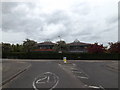
10
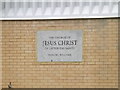
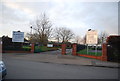
Church of Jesus Christ of Latter Day Saints sign
Off Sidegate Lane west
Image: © Geographer
Taken: 1 Jun 2015
0.11 miles