IMAGES TAKEN NEAR TO
Colchester Road, IPSWICH, IP4 3BT
Introduction
This page details the photographs taken nearby to Colchester Road, IP4 3BT by members of the Geograph project.
The Geograph project started in 2005 with the aim of publishing, organising and preserving representative images for every square kilometre of Great Britain, Ireland and the Isle of Man.

There are currently over 7.5m images from over14,400 individuals and you can help contribute to the project by visiting https://www.geograph.org.uk
Image Map
Images are licensed for reuse under creativecommons.org/licenses/by-sa/2.0
Notes
- Clicking on the map will re-center to the selected point.
- The higher the marker number, the further away the image location is from the centre of the postcode.
Image Listing (63 Images Found)
Images are licensed for reuse under creativecommons.org/licenses/by-sa/2.0
Image
Details
Distance
3
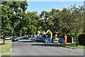
Roadworks on Tuddenham Road
Looking north-east from the junction with Chelsworth Avenue.
Image: © Simon Mortimer
Taken: 10 Sep 2020
0.07 miles
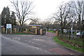
5
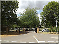
Cemetery entrance, Westerfield, Ipswich
At the junction with Cemetery Lane
Image: © Geographer
Taken: 23 Jul 2015
0.08 miles
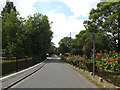
6
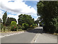
Cemetery Lane, Westerfield, Ipswich
Looking towards the A1214 Colchester Road
Image: © Geographer
Taken: 23 Jul 2015
0.08 miles
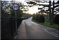
9
Cemetery Lane, Westerfield, Ipswich
Near the junction with the A1214 Colchester Road
Image: © Geographer
Taken: 23 Jul 2015
0.09 miles
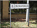
10
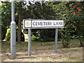
Cemetery Lane sign
On Cemetery Lane at the junction with the A1214 Colchester Road
Image: © Geographer
Taken: 23 Jul 2015
0.09 miles