IMAGES TAKEN NEAR TO
Vermont Close, IPSWICH, IP4 2SA
Introduction
This page details the photographs taken nearby to Vermont Close, IP4 2SA by members of the Geograph project.
The Geograph project started in 2005 with the aim of publishing, organising and preserving representative images for every square kilometre of Great Britain, Ireland and the Isle of Man.

There are currently over 7.5m images from over14,400 individuals and you can help contribute to the project by visiting https://www.geograph.org.uk
Image Map
Images are licensed for reuse under creativecommons.org/licenses/by-sa/2.0
Notes
- Clicking on the map will re-center to the selected point.
- The higher the marker number, the further away the image location is from the centre of the postcode.
Image Listing (113 Images Found)
Images are licensed for reuse under creativecommons.org/licenses/by-sa/2.0
Image
Details
Distance
1
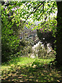
Terraced cottages at the southern end of Ipswich Old Cemetery
Image: © Evelyn Simak
Taken: 20 Apr 2011
0.11 miles
3
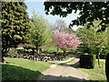
Cherry tree in Ipswich Old Municipal Cemetery
Image: © Adrian S Pye
Taken: 20 Apr 2011
0.12 miles
4
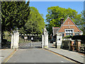
Ipswich Old Cemetery gates
The building to the right is the stone mason's workshop
Image: © Adrian S Pye
Taken: 20 Apr 2011
0.12 miles
6
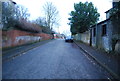
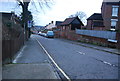
Hervey Street, Ipswich
At the junction with the B1077 Tuddenham Road & Constable Road
Image: © Geographer
Taken: 2 Nov 2015
0.12 miles
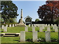
7
Ipswich Old Cemetery, WWII Field of Remembrance
Image: © Adrian S Pye
Taken: 20 Apr 2011
0.12 miles
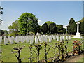
8
Ipswich Old Cemetery, WWI Field of Remembrance
Image: © Adrian S Pye
Taken: 20 Apr 2011
0.12 miles
10
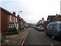
Hervey Street, Ipswich
At the junction with the B1077 Tuddenham Road & Constable Road
Image: © Geographer
Taken: 2 Nov 2015
0.12 miles