IMAGES TAKEN NEAR TO
Nursery Gardens, IPSWICH, IP4 2RW
Introduction
This page details the photographs taken nearby to Nursery Gardens, IP4 2RW by members of the Geograph project.
The Geograph project started in 2005 with the aim of publishing, organising and preserving representative images for every square kilometre of Great Britain, Ireland and the Isle of Man.

There are currently over 7.5m images from over14,400 individuals and you can help contribute to the project by visiting https://www.geograph.org.uk
Image Map
Images are licensed for reuse under creativecommons.org/licenses/by-sa/2.0
Notes
- Clicking on the map will re-center to the selected point.
- The higher the marker number, the further away the image location is from the centre of the postcode.
Image Listing (46 Images Found)
Images are licensed for reuse under creativecommons.org/licenses/by-sa/2.0
Image
Details
Distance
1
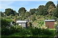
Allotments at Spring Road, Ipswich
The allotments have occupied this steep site on Spring Road since at least the 1920s.
Image: © Simon Mortimer
Taken: 10 Sep 2020
0.10 miles
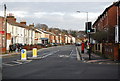
5
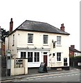
The Duke of York
Half way up the hill on the corner of Woodbridge and Warwick Roads Ipswich
Image: © Jay O'Dea
Taken: 24 Aug 2011
0.13 miles
9
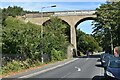
Spring Road viaduct, Ipswich
The viaduct carries the Ipswich to Felixstowe branch line, opened in 1877, over Spring Road.
Image: © Simon Mortimer
Taken: 10 Sep 2020
0.15 miles
10
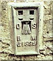
Flush Bracket OSBM G1599 Ipswich Spring Road Viaduct
Flush Bracket OSBM G1599 Ipswich Spring Road Viaduct, S side of Spring Road W buttress.
Image: © Cud05
Taken: 13 Apr 2016
0.16 miles