IMAGES TAKEN NEAR TO
West Road, IPSWICH, IP3 9TT
Introduction
This page details the photographs taken nearby to West Road, IP3 9TT by members of the Geograph project.
The Geograph project started in 2005 with the aim of publishing, organising and preserving representative images for every square kilometre of Great Britain, Ireland and the Isle of Man.

There are currently over 7.5m images from over14,400 individuals and you can help contribute to the project by visiting https://www.geograph.org.uk
Image Map
Images are licensed for reuse under creativecommons.org/licenses/by-sa/2.0
Notes
- Clicking on the map will re-center to the selected point.
- The higher the marker number, the further away the image location is from the centre of the postcode.
Image Listing (7 Images Found)
Images are licensed for reuse under creativecommons.org/licenses/by-sa/2.0
Image
Details
Distance
1
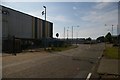
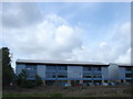
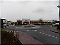
Central Avenue, Ransomes Europark, Ipswich
The industrial estate, deserted on a Saturday afternoon, has several of its roads closed off by barriers, presumably to prevent them being used for rat-runs or racing.
On the left, the depot of Debach haulage, which takes its name from a village a few miles further north.
Image: © Christopher Hilton
Taken: 24 Aug 2019
0.10 miles

5
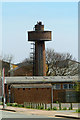
Water tower combined with factory chimney
An unusual combination that uses waste heat to prevent the water freezing.
Image: © Nat Bocking
Taken: 3 May 2006
0.22 miles
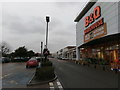
7
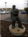
"Man with Ball" sculpture, Ransomes Europark, Ipswich
Image: © Christopher Hilton
Taken: 14 Feb 2018
0.24 miles