IMAGES TAKEN NEAR TO
Damselfly Road, IPSWICH, IP3 9TS
Introduction
This page details the photographs taken nearby to Damselfly Road, IP3 9TS by members of the Geograph project.
The Geograph project started in 2005 with the aim of publishing, organising and preserving representative images for every square kilometre of Great Britain, Ireland and the Isle of Man.

There are currently over 7.5m images from over14,400 individuals and you can help contribute to the project by visiting https://www.geograph.org.uk
Image Map
Images are licensed for reuse under creativecommons.org/licenses/by-sa/2.0
Notes
- Clicking on the map will re-center to the selected point.
- The higher the marker number, the further away the image location is from the centre of the postcode.
Image Listing (37 Images Found)
Images are licensed for reuse under creativecommons.org/licenses/by-sa/2.0
Image
Details
Distance
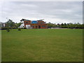
1
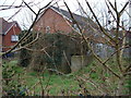
Pillbox on Wyvern Road
This pillbox now stands covered in vegetation and looking rather forlorn in the middle of a new housing estate. The Ravenswood estate was built on the site of Ipswich airport, and presumably the pillbox was erected to protect the airfield during WW2. It's a little surprising that the pillbox wasn't demolished during the building of the new houses.
Image: © Oxymoron
Taken: 31 Dec 2008
0.07 miles
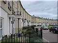
3
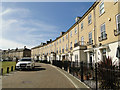
Bonney Crescent, Ipswich
Reminiscent of Bath with modern houses
Image: © Adrian S Pye
Taken: 10 Mar 2015
0.15 miles
6
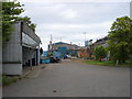
The Crane Works
I believe that "Crane" is the name of the company, rather than a description of what used to be made here. This is a big site, and a board outside proclaims "44 acre site acquired for development", so I don't suppose these buildings will be around much longer (credit crunch permitting, I suppose).
Image: © Oxymoron
Taken: 17 May 2009
0.18 miles
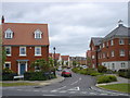
7
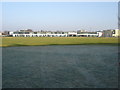
Terraced housing on the site of the old Ipswich airport terminal
Image: © Oxymoron
Taken: 30 Dec 2008
0.19 miles

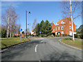
10
Lindbergh Road, Priory Heath, Ipswich
At the junction with Nacton Road
Image: © Geographer
Taken: 25 Sep 2014
0.20 miles