IMAGES TAKEN NEAR TO
Rosehill Road, IPSWICH, IP3 8HG
Introduction
This page details the photographs taken nearby to Rosehill Road, IP3 8HG by members of the Geograph project.
The Geograph project started in 2005 with the aim of publishing, organising and preserving representative images for every square kilometre of Great Britain, Ireland and the Isle of Man.

There are currently over 7.5m images from over14,400 individuals and you can help contribute to the project by visiting https://www.geograph.org.uk
Image Map
Images are licensed for reuse under creativecommons.org/licenses/by-sa/2.0
Notes
- Clicking on the map will re-center to the selected point.
- The higher the marker number, the further away the image location is from the centre of the postcode.
Image Listing (86 Images Found)
Images are licensed for reuse under creativecommons.org/licenses/by-sa/2.0
Image
Details
Distance
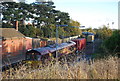
6
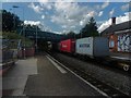
Derby Road station, Ipswich
View down platform 1 towards the bridge carrying Derby Road, which gives the station its name, over the Ipswich to Felixstowe railway line.
Image: © Ed of the South
Taken: 21 Jun 2014
0.05 miles
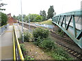
10
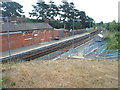
Derby Road (Ipswich) railway station
Opened in 1877 by the Felixstowe Rail and Pier Company on its line from Ipswich to Felixstowe Beach. View east towards Trimley and Felixstowe.
Image: © Nigel Thompson
Taken: 4 Jul 2009
0.07 miles