IMAGES TAKEN NEAR TO
Myrtle Close, BURY ST. EDMUNDS, IP33 3ZB
Introduction
This page details the photographs taken nearby to Myrtle Close, IP33 3ZB by members of the Geograph project.
The Geograph project started in 2005 with the aim of publishing, organising and preserving representative images for every square kilometre of Great Britain, Ireland and the Isle of Man.

There are currently over 7.5m images from over14,400 individuals and you can help contribute to the project by visiting https://www.geograph.org.uk
Image Map
Images are licensed for reuse under creativecommons.org/licenses/by-sa/2.0
Notes
- Clicking on the map will re-center to the selected point.
- The higher the marker number, the further away the image location is from the centre of the postcode.
Image Listing (124 Images Found)
Images are licensed for reuse under creativecommons.org/licenses/by-sa/2.0
Image
Details
Distance
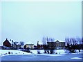
1
Icy riverlet in Tayfen Estate
The icy surface is reflecting a sunset which is hard to detect in the rest of the scene. This is the level of snow that Bury St. Edmunds got this winter when the rest of the country were under several feet of the stuff.
Image: © John Goldsmith
Taken: 9 Jan 2011
0.01 miles
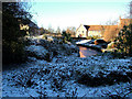
2
Ice and Snow
Refashioned water channel in modern housing development takes on softer edge during cold snap.
Image: © Stuart Shepherd
Taken: 5 Feb 2012
0.03 miles
4
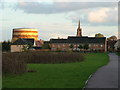
"Our house has a spire"
"Well ours has a gas holder". The Tayfen estate near sunset, featuring (in the next square) St. John's church tower and the Tayfen Road gasholder.
The area in the foreground was actually sown with different seed mixtures and the contrast has become quite pronounced, especially as the rabbits seem to only like one.
Image: © John Goldsmith
Taken: 29 Oct 2008
0.04 miles
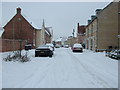
5

Fen Way on Tayfen estate, with black cloud
Not too long ago this was a caravan park and greyhound track.
Image: © John Goldsmith
Taken: 22 Jan 2012
0.05 miles
6
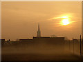
Misty morning, Tayfen Meadow
The skyline is dominated by the spire of St. John's church.
There are a lot of Poles in Bury St. Edmunds, but on the right we have a new set of poles - the installation of lights by the path. Half the path was lit years ago but the remainder has remained dangerously dark.
Image: © John Goldsmith
Taken: 21 Nov 2011
0.05 miles
7
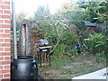
Brick Built Shelter (2)
Close up detail.
Image: © Stuart Shepherd
Taken: 30 Jul 2008
0.05 miles
8
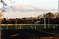
Greyhound track, about 1995
The greyhound track is viewed over the roof of the kennels, though not much is visible apart from the white fence, and the posts for the lighting and sound systems. This area now forms part of the Tayfen housing estate. Beyond the track we see the Triton House office blocks, while the rusty brown of the gasholder just appears on the left.
Image: © John Goldsmith
Taken: Unknown
0.06 miles
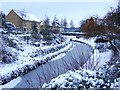
9
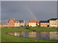
Tayfen estate and lake with rainbow
This part of the Tayfen estate was built on the old greyhound racing track. The lake was made from the former marsh, while the land was built up and the houses placed on piles, with the little no-name river run through a deep landscaped channel.
Image: © John Goldsmith
Taken: 26 Apr 2005
0.06 miles