IMAGES TAKEN NEAR TO
St. Marys Court, Mill Road, BURY ST. EDMUNDS, IP33 3XP
Introduction
This page details the photographs taken nearby to St. Marys Court, Mill Road, IP33 3XP by members of the Geograph project.
The Geograph project started in 2005 with the aim of publishing, organising and preserving representative images for every square kilometre of Great Britain, Ireland and the Isle of Man.

There are currently over 7.5m images from over14,400 individuals and you can help contribute to the project by visiting https://www.geograph.org.uk
Image Map
Images are licensed for reuse under creativecommons.org/licenses/by-sa/2.0
Notes
- Clicking on the map will re-center to the selected point.
- The higher the marker number, the further away the image location is from the centre of the postcode.
Image Listing (224 Images Found)
Images are licensed for reuse under creativecommons.org/licenses/by-sa/2.0
Image
Details
Distance
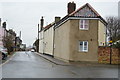
3
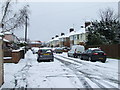
Castle Road
Castle Road in the snow Bury St.Edmunds Suffolk.
Image: © Keith Evans
Taken: 23 Mar 2008
0.04 miles
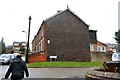
4

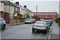
Castle Road, Bury St Edmunds
A residential road turned into a cul de sac by Parkway (behind the photographer).
Image: © Richard Vince
Taken: 3 Feb 2018
0.05 miles
6

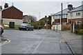
Parkway, Bury St Edmunds (2)
Forming an inner bypass around the west side of the town centre.
Image: © Richard Vince
Taken: 3 Feb 2018
0.05 miles
9
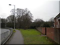
Open space next to Parkway, Bury St Edmunds
Image: © Richard Vince
Taken: 3 Feb 2018
0.07 miles
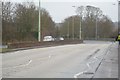
10
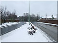
Snow covered Parkway
Looking south along the Parkway Bury St.Edmunds Suffolk.
Image: © Keith Evans
Taken: 23 Mar 2008
0.07 miles