
IMAGES TAKEN NEAR TO
The Beeches, Out Risbygate, BURY ST. EDMUNDS, IP33 3RD
Introduction
This page details the photographs taken nearby to The Beeches, Out Risbygate, IP33 3RD by members of the Geograph project.
The Geograph project started in 2005 with the aim of publishing, organising and preserving representative images for every square kilometre of Great Britain, Ireland and the Isle of Man.

There are currently over 7.5m images from over14,400 individuals and you can help contribute to the project by visiting https://www.geograph.org.uk
Image Map
Images are licensed for reuse under creativecommons.org/licenses/by-sa/2.0
Notes
- Clicking on the map will re-center to the selected point.
- The higher the marker number, the further away the image location is from the centre of the postcode.
Image Listing (101 Images Found)
Images are licensed for reuse under creativecommons.org/licenses/by-sa/2.0
Image
Details
Distance
1
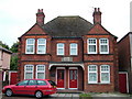
Suffolk Regiment Cottages
These cottages commemorate the South African War (Boer War) 1899 - 1902. In the centre of Bury St. Edmunds there is a statue to the dead in that war, which you can see here Image The plaques on the front of the cottages can be seen at Image
Image: © John Goldsmith
Taken: 6 Sep 2008
0.01 miles
2
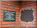
Plaques, Suffolk Regiment homes
Plaques old and new give details of the cottages seen at Image
Image: © John Goldsmith
Taken: 8 Sep 2008
0.01 miles
3
![Bury St Edmunds buildings [245]](https://s3.geograph.org.uk/geophotos/06/69/90/6699051_18483f2c_120x120.jpg)
Bury St Edmunds buildings [245]
Part of the outer walls of Gibraltar Barracks with the top of the keep visible. The high walls are in red brick, divided into bays by pilasters, on a high plinth and with a projecting top with rounded copings.
The keep and the walls are the remaining parts of a much larger depot complex
built in 1878 as part of the army's 'localisation' process which was intended to improve the ties between a regiment and its locality to assist recruitment. The keep raised the local profile of the barracks, and provided a focus for the regiment. The depot ceased to be used in 1960 and is now The Suffolk Regimental Museum. Listed, grade II with details of the keep at: https://historicengland.org.uk/listing/the-list/list-entry/1244805 and details of the walls at: https://historicengland.org.uk/listing/the-list/list-entry/1244844
Brentgovel Street and Risbygate Street was a prosperous area in the fifteenth century but it became neglected and decay had set in. In the 1990s, a Conservation Area Partnership Schemes was introduced to give a new lease of life into the area by repairing and reusing historic buildings. Forty-five new residential units and ten new retail units have resulted in the area thriving again.
Bury St Edmunds is a market town which is the cultural and retail centre for West Suffolk and is known for brewing (Greene King) and sugar (British Sugar). There is scattered evidence of earlier activity but essentially Bury St Edmunds began as one of the royal boroughs of the Saxons and a monastery was founded which became the burial place of King Edmund. A new Benedictine abbey was built in 1020 which became rich and powerful and the town was laid out on a grid pattern by Abbot Baldwin. After the dissolution the abbey became ruinous. A new church, later the cathedral, was begun in the early 16th century.
Image: © Michael Dibb
Taken: 11 Sep 2020
0.03 miles
4
![Bury St Edmunds buildings [247]](https://s2.geograph.org.uk/geophotos/06/69/90/6699054_494b22f0_120x120.jpg)
Bury St Edmunds buildings [247]
Part of the outer walls of Gibraltar Barracks. The high walls are in red brick, divided into bays by pilasters, on a high plinth and with a projecting top with rounded copings.
The keep and the walls are the remaining parts of a much larger depot complex
built in 1878 as part of the army's 'localisation' process which was intended to improve the ties between a regiment and its locality to assist recruitment. The keep raised the local profile of the barracks, and provided a focus for the regiment. The depot ceased to be used in 1960 and is now The Suffolk Regimental Museum. Listed, grade II with details of the keep at: https://historicengland.org.uk/listing/the-list/list-entry/1244805 and details of the walls at: https://historicengland.org.uk/listing/the-list/list-entry/1244844
Brentgovel Street and Risbygate Street was a prosperous area in the fifteenth century but it became neglected and decay had set in. In the 1990s, a Conservation Area Partnership Schemes was introduced to give a new lease of life into the area by repairing and reusing historic buildings. Forty-five new residential units and ten new retail units have resulted in the area thriving again.
Bury St Edmunds is a market town which is the cultural and retail centre for West Suffolk and is known for brewing (Greene King) and sugar (British Sugar). There is scattered evidence of earlier activity but essentially Bury St Edmunds began as one of the royal boroughs of the Saxons and a monastery was founded which became the burial place of King Edmund. A new Benedictine abbey was built in 1020 which became rich and powerful and the town was laid out on a grid pattern by Abbot Baldwin. After the dissolution the abbey became ruinous. A new church, later the cathedral, was begun in the early 16th century.
Image: © Michael Dibb
Taken: 11 Sep 2020
0.04 miles
5
![Bury St Edmunds buildings [246]](https://s1.geograph.org.uk/geophotos/06/69/90/6699053_20ec6fe4_120x120.jpg)
Bury St Edmunds buildings [246]
The keep of Gibraltar Barracks built in red brick with white brick and ashlar dressings. The walls are topped by a high crenellated parapet. The towers, which contain the stairs, have a row of three narrow stepped windows to each storey and the projecting top is crenellated above a row of stone machicolations.
The keep and the walls are the remaining parts of a much larger depot complex
built in 1878 as part of the army's 'localisation' process which was intended to improve the ties between a regiment and its locality to assist recruitment. The keep raised the local profile of the barracks, and provided a focus for the regiment. The depot ceased to be used in 1960 and is now The Suffolk Regimental Museum. Listed, grade II with details of the keep at: https://historicengland.org.uk/listing/the-list/list-entry/1244805 and details of the walls at: https://historicengland.org.uk/listing/the-list/list-entry/1244844
Brentgovel Street and Risbygate Street was a prosperous area in the fifteenth century but it became neglected and decay had set in. In the 1990s, a Conservation Area Partnership Schemes was introduced to give a new lease of life into the area by repairing and reusing historic buildings. Forty-five new residential units and ten new retail units have resulted in the area thriving again.
Bury St Edmunds is a market town which is the cultural and retail centre for West Suffolk and is known for brewing (Greene King) and sugar (British Sugar). There is scattered evidence of earlier activity but essentially Bury St Edmunds began as one of the royal boroughs of the Saxons and a monastery was founded which became the burial place of King Edmund. A new Benedictine abbey was built in 1020 which became rich and powerful and the town was laid out on a grid pattern by Abbot Baldwin. After the dissolution the abbey became ruinous. A new church, later the cathedral, was begun in the early 16th century.
Image: © Michael Dibb
Taken: 11 Sep 2020
0.04 miles
6
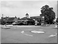
Study of a Gasoline Station
Texaco, Bury St Edmunds.
This photograph is part of a series taken in homage to the American artist Ed Ruscha's 1963 publication of 'Twentysix Gasoline Stations'.
More properly known as filling stations in the UK, I am attempting to photograph as many as possible to mark the sixty year anniversary.
Image: © David Bremner
Taken: 9 May 2023
0.04 miles
7
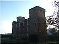
Rear of The Keep, Gibraltar barracks building
The old barracks building houses the museum of the Suffolk Regiment, now absorbed into the Royal Anglian Regiment.
For more details see
http://www.suffolkregiment.org/Museum.html
http://www.stedmundsbury.gov.uk/sebc/visit/sufreg.cfm
Image: © John Goldsmith
Taken: 20 Nov 2011
0.05 miles
9
![Bury St Edmunds buildings [248]](https://s2.geograph.org.uk/geophotos/06/69/90/6699058_7e2dac1b_120x120.jpg)
Bury St Edmunds buildings [248]
The main entrance to Gibraltar Barracks has high, wide wrought-iron gates flanked by small side gates. Each pair of gate piers is linked above the side gates by brickwork, with stone capping and a stone block, on the left a shield dated 1878, on the right with the interwoven letters VR.
The keep and the walls are the remaining parts of a much larger depot complex
built in 1878 as part of the army's 'localisation' process which was intended to improve the ties between a regiment and its locality to assist recruitment. The keep raised the local profile of the barracks, and provided a focus for the regiment. The depot ceased to be used in 1960 and is now The Suffolk Regimental Museum. Listed, grade II with details of the keep at: https://historicengland.org.uk/listing/the-list/list-entry/1244805 and details of the walls at: https://historicengland.org.uk/listing/the-list/list-entry/1244844
Brentgovel Street and Risbygate Street was a prosperous area in the fifteenth century but it became neglected and decay had set in. In the 1990s, a Conservation Area Partnership Schemes was introduced to give a new lease of life into the area by repairing and reusing historic buildings. Forty-five new residential units and ten new retail units have resulted in the area thriving again.
Bury St Edmunds is a market town which is the cultural and retail centre for West Suffolk and is known for brewing (Greene King) and sugar (British Sugar). There is scattered evidence of earlier activity but essentially Bury St Edmunds began as one of the royal boroughs of the Saxons and a monastery was founded which became the burial place of King Edmund. A new Benedictine abbey was built in 1020 which became rich and powerful and the town was laid out on a grid pattern by Abbot Baldwin. After the dissolution the abbey became ruinous. A new church, later the cathedral, was begun in the early 16th century.
Image: © Michael Dibb
Taken: 11 Sep 2020
0.05 miles
10
Royal Anglian Regiment Headquarters, Bury St. Edmunds
Image: © Bikeboy
Taken: 10 Apr 2013
0.05 miles