IMAGES TAKEN NEAR TO
Albert Crescent, BURY ST. EDMUNDS, IP33 3DX
Introduction
This page details the photographs taken nearby to Albert Crescent, IP33 3DX by members of the Geograph project.
The Geograph project started in 2005 with the aim of publishing, organising and preserving representative images for every square kilometre of Great Britain, Ireland and the Isle of Man.

There are currently over 7.5m images from over14,400 individuals and you can help contribute to the project by visiting https://www.geograph.org.uk
Image Map
Images are licensed for reuse under creativecommons.org/licenses/by-sa/2.0
Notes
- Clicking on the map will re-center to the selected point.
- The higher the marker number, the further away the image location is from the centre of the postcode.
Image Listing (148 Images Found)
Images are licensed for reuse under creativecommons.org/licenses/by-sa/2.0
Image
Details
Distance
1
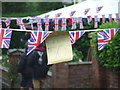
Back To The 50s
Sign seen on bunting as the residents of Albert Crescent in Bury St. Edmunds Suffolk prepare for a Diamond Jubilee 2012 street party. For full view of the preparations see http://www.geograph.org.uk/photo/2974448
Image: © Keith Evans
Taken: 3 Jun 2012
0.02 miles
2
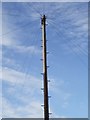
Telephone lines
Telephone pole and wires Albert Crescent Bury St.Edmunds Suffolk.
Image: © Keith Evans
Taken: 9 Mar 2008
0.02 miles
3
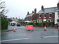
Street Party
Residents of Albert Crescent in Bury St. Edmunds Suffolk preparing for what's looks like will be a rather wet Diamond Jubilee 2012 street party.
Image: © Keith Evans
Taken: 3 Jun 2012
0.03 miles
4
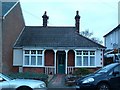
Old Bungalow
Old bungalow in Albert Crescent, Bury St Edmunds Suffolk.
Image: © Keith Evans
Taken: 1 Jan 2007
0.04 miles
5
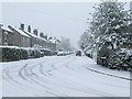
Queens Road in the snow
Looking west along Queens Road in the snow Bury St.Edmunds Suffolk.
Image: © Keith Evans
Taken: 23 Mar 2008
0.06 miles
6
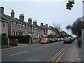
Queens Road Bury St Edmunds Christmas Day 2006
Photo of Queens Road, Bury St Edmunds taken at 12-30 PM on Christmas day 2006. On a normal Monday at this time of day this road would be busy with cars and buses as a main thoroughfare from the outskirts to the town centre.
Image: © Keith Evans
Taken: 25 Dec 2006
0.06 miles
7
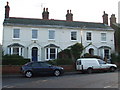
Albion Villas
Albion Villas 1897 Albert Crescent Bury St.Edmunds Suffolk.
Image: © Keith Evans
Taken: 30 Dec 2008
0.06 miles
8
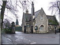
Former cemetery office
This was the cemetery office guarding the gates. I believe it is now rented housing by the local council. Kings Road, Bury St. Edmunds Suffolk on a non-white but wet Christmas day.
Image: © Keith Evans
Taken: 25 Dec 2007
0.06 miles
9
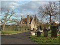
![Bury St Edmunds buildings [264]](https://s0.geograph.org.uk/geophotos/06/70/47/6704720_86fad10d_120x120.jpg)
Bury St Edmunds buildings [264]
The lodge to Bury St Edmunds cemetery was built in 1855 when the cemetery was opened. Constructed in ragstone with ashlar dressings. The cemetery is located at the end of King's Road which was formerly Cemetery Road. Listed, grade II, with details at: https://historicengland.org.uk/listing/the-list/list-entry/1022577
Much of the centre of the town has suffered from redevelopment and most buildings are later than the mid 19th century. There are some uninspiring modern buildings along Parkway and the Arc shopping centre is particularly ugly, especially the building occupied by Debenhams.
Bury St Edmunds is a market town which is the cultural and retail centre for West Suffolk and is known for brewing (Greene King) and sugar (British Sugar). There is scattered evidence of earlier activity but essentially Bury St Edmunds began as one of the royal boroughs of the Saxons and a monastery was founded which became the burial place of King Edmund. A new Benedictine abbey was built in 1020 which became rich and powerful and the town was laid out on a grid pattern by Abbot Baldwin. After the dissolution the abbey became ruinous. A new church, later the cathedral, was begun in the early 16th century.
Image: © Michael Dibb
Taken: 11 Sep 2020
0.07 miles
10
Cemetery Office
Cemetery office at the entrance to Bury St.Edmunds Cemetery.
Image: © Keith Evans
Taken: 17 Dec 2006
0.07 miles