IMAGES TAKEN NEAR TO
Spring Lane, BURY ST. EDMUNDS, IP33 3AP
Introduction
This page details the photographs taken nearby to Spring Lane, IP33 3AP by members of the Geograph project.
The Geograph project started in 2005 with the aim of publishing, organising and preserving representative images for every square kilometre of Great Britain, Ireland and the Isle of Man.

There are currently over 7.5m images from over14,400 individuals and you can help contribute to the project by visiting https://www.geograph.org.uk
Image Map
Images are licensed for reuse under creativecommons.org/licenses/by-sa/2.0
Notes
- Clicking on the map will re-center to the selected point.
- The higher the marker number, the further away the image location is from the centre of the postcode.
Image Listing (153 Images Found)
Images are licensed for reuse under creativecommons.org/licenses/by-sa/2.0
Image
Details
Distance
1
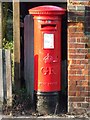
G R Postbox
G R Postbox Springfield Road Bury St.Edmunds Suffolk.
Image: © Keith Evans
Taken: 30 Dec 2008
0.05 miles
2
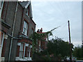
Telephone line creeper
On the western side of Springfield Road. The neighbouring houses are Nelson Villa and Trafalgar Villa, which may be a clue to their age. But the terraces further down the road are dated 1896 to 1900.
Image: © John Goldsmith
Taken: 8 Sep 2008
0.08 miles
3
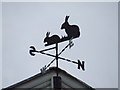
Bunny weather vane
Bunny weather vane above the entrance of St.Edmunds primary school Grove road Bury St.Edmunds Suffolk.
Image: © Keith Evans
Taken: 2 Dec 2007
0.08 miles
4
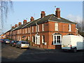
Cornfield Road
Victorian houses Cornfield Road Burt St.Edmunds Suffolk.
Image: © Keith Evans
Taken: 30 Dec 2008
0.09 miles
5
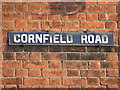
Cornfield Road sign
Old enamelled road sign for Cornfield Road Bury St.Edmunds Suffolk.
Image: © Keith Evans
Taken: 30 Dec 2008
0.10 miles
6
Brick Built Shelter
A rare relic from WW2
Image: © Stuart Shepherd
Taken: 29 Jul 2008
0.10 miles
7
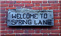
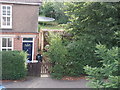
Welcome to Spring Lane
This sign is actually flanked by a couple of hooks for hanging baskets, but sadly none are fitted. The sign was erected in the 1980s when an area of allotments was converted to be a temporary wildlife area pending the construction of housing. The area attracted lots of 'green' people, hippies and tree huggers, then when the houses were finally planned they said 'You can't destroy our wild area'. So far they have their way. It provides an interesting contrast to an adjacent slightly more managed park area, and then the Tayfen Meadows estate.
Image: © John Goldsmith
Taken: 8 Jun 2009
0.11 miles
8
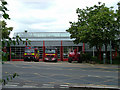
Fire station cleaning, Parkway, Bury St. Edmunds
The appliances have been moved outside while the building has a thorough cleaning, using the 'cherry picker' vehicle on the right.
Image: © John Goldsmith
Taken: 3 Jun 2009
0.11 miles
9
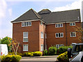
Block 1, Trinity Mews
Built 1987. 9 flats in this block, but there are 5 other blocks.
Image: © John Goldsmith
Taken: 11 Aug 2007
0.11 miles
10
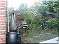
Brick Built Shelter (2)
Close up detail.
Image: © Stuart Shepherd
Taken: 30 Jul 2008
0.12 miles