IMAGES TAKEN NEAR TO
Risbygate Street, BURY ST. EDMUNDS, IP33 3AD
Introduction
This page details the photographs taken nearby to Risbygate Street, IP33 3AD by members of the Geograph project.
The Geograph project started in 2005 with the aim of publishing, organising and preserving representative images for every square kilometre of Great Britain, Ireland and the Isle of Man.

There are currently over 7.5m images from over14,400 individuals and you can help contribute to the project by visiting https://www.geograph.org.uk
Image Map
Images are licensed for reuse under creativecommons.org/licenses/by-sa/2.0
Notes
- Clicking on the map will re-center to the selected point.
- The higher the marker number, the further away the image location is from the centre of the postcode.
Image Listing (274 Images Found)
Images are licensed for reuse under creativecommons.org/licenses/by-sa/2.0
Image
Details
Distance
1
Risbygate Street, Bury St Edmunds
Showing position of Postbox No. IP33 2049.
See Image] for postbox.
Image: © JThomas
Taken: 21 May 2016
0.02 miles
2
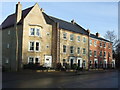
New houses
New houses out Risbygate street Bury St.Edmunds Suffolk.
Image: © Keith Evans
Taken: 23 Dec 2007
0.02 miles
3
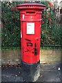
Postbox
Postbox with graffiti Out Risbygate street Bury St.Edmunds Suffolk.
Image: © Keith Evans
Taken: 23 Dec 2007
0.02 miles
4
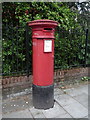
Postbox on Risbygate Street, Bury St Edmunds
Postbox No. IP33 2049.
Image: © JThomas
Taken: 21 May 2016
0.03 miles
5
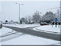
Parkway in the snow
The Parkway in the snow Bury St.Edmunds Suffolk.
Image: © Keith Evans
Taken: 23 Mar 2008
0.04 miles
6
![Bury St Edmunds features [40]](https://s1.geograph.org.uk/geophotos/06/69/82/6698241_6bf52d77_120x120.jpg)
Bury St Edmunds features [40]
On the roundabout where Risbygate Street crosses Parkway is this sculpture of St Edmund in his martyrdom, made from steel wire with steel arrows penetrating Edmund’s heart and body.
The Legend of St Edmund and the Wolf
Edmund, King of East Anglia, fought against the Danes but was captured. When he refused to give up his Christian faith the Danes tied him to a tree, shot him with arrows until he ‘bristled like a hedgehog’ and then decapitated him. The King’s men came to find his body after the battle, but they could not find his head. Hearing a cry of ‘Here, here, here’ from a nearby wood, they discovered a wolf protecting the head of the King. The wolf allowed the men to take the head and, when placed with the body, a miracle occurred and the head fused back on. This was felt to be a sign of sainthood and many miracles were then attributed to Edmund and his shrine in the Abbey of Bury St Edmunds became a place of pilgrimage.
Brentgovel Street and Risbygate Street was a prosperous area in the fifteenth century but it became neglected and decay had set in. In the 1990s, a Conservation Area Partnership Schemes was introduced to give a new lease of life into the area by repairing and reusing historic buildings. Forty five new residential units and ten new retail units have resulted in the area thriving again.
Bury St Edmunds is a market town which is the cultural and retail centre for West Suffolk and is known for brewing (Greene King) and sugar (British Sugar). There is scattered evidence of earlier activity but essentially Bury St Edmunds began as one of the royal boroughs of the Saxons and a monastery was founded which became the burial place of King Edmund. A new Benedictine abbey was built in 1020 which became rich and powerful and the town was laid out on a grid pattern by Abbot Baldwin. After the dissolution the abbey became ruinous. A new church, later the cathedral, was begun in the early 16th century.
Image: © Michael Dibb
Taken: 13 Sep 2020
0.04 miles
7
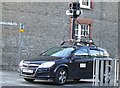
Caught In The Act
Google car seen waiting at the end of Springfield Road Bury St.Edmunds, Suffolk at 15.56 06-03-09.
Image: © Keith Evans
Taken: 6 Mar 2009
0.05 miles