IMAGES TAKEN NEAR TO
Hardwick Lane, BURY ST. EDMUNDS, IP33 2RB
Introduction
This page details the photographs taken nearby to Hardwick Lane, IP33 2RB by members of the Geograph project.
The Geograph project started in 2005 with the aim of publishing, organising and preserving representative images for every square kilometre of Great Britain, Ireland and the Isle of Man.

There are currently over 7.5m images from over14,400 individuals and you can help contribute to the project by visiting https://www.geograph.org.uk
Image Map
Images are licensed for reuse under creativecommons.org/licenses/by-sa/2.0
Notes
- Clicking on the map will re-center to the selected point.
- The higher the marker number, the further away the image location is from the centre of the postcode.
Image Listing (33 Images Found)
Images are licensed for reuse under creativecommons.org/licenses/by-sa/2.0
Image
Details
Distance
4
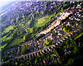
Baron's Road and "The Greens"
Taken from a model aircraft over Hardwick Heath, this photo reveals Hardwick Lane just visible at bottom right. Then the row of bungalows on the south side of Barons Road. To the north there are a series of looped roads, each called "Xxxx Green" - you can see the grass and trees in the centre of each. The building site behind used to be an industrial estate based round the Victorian Hand Laundry - this is now becoming a housing estate.
Cullum Road slices across the water meadows (controversial when it was built) then curves off into the town top left, with the medieval rectangular grid pattern just visible in the haze. The setting sun highlights the Abbey, Cathedral and St. Mary's church in the same road, at about 11 o'clock on the frame.
Image: © John Goldsmith
Taken: 12 Jun 2010
0.07 miles
7
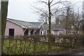
The Lodge
Grade II listed. https://www.britishlistedbuildings.co.uk/101246709-the-lodge-bury-st-edmunds
Image: © N Chadwick
Taken: 10 Feb 2018
0.10 miles
8
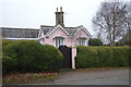
The Lodge
Grade II listed. https://www.britishlistedbuildings.co.uk/101246709-the-lodge-bury-st-edmunds
Image: © N Chadwick
Taken: 10 Feb 2018
0.11 miles
9
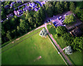
Entrance to Hardwick Heath from the air
A driveway turns off Hardwick Lane (seen at top left) to the pay car park top right. The concrete track, not open to the public, leads to the other end of the so-called heath - a set of mowed grass areas and clumps of trees.
The model aircraft carrying the camera is over the fenced football fields.
Image: © John Goldsmith
Taken: 12 Jun 2010
0.12 miles