
IMAGES TAKEN NEAR TO
Mayfield Road, BURY ST. EDMUNDS, IP33 2PB
Introduction
This page details the photographs taken nearby to Mayfield Road, IP33 2PB by members of the Geograph project.
The Geograph project started in 2005 with the aim of publishing, organising and preserving representative images for every square kilometre of Great Britain, Ireland and the Isle of Man.

There are currently over 7.5m images from over14,400 individuals and you can help contribute to the project by visiting https://www.geograph.org.uk
Image Map
Images are licensed for reuse under creativecommons.org/licenses/by-sa/2.0
Notes
- Clicking on the map will re-center to the selected point.
- The higher the marker number, the further away the image location is from the centre of the postcode.
Image Listing (6 Images Found)
Images are licensed for reuse under creativecommons.org/licenses/by-sa/2.0
Image
Details
Distance

2

Townlane Road
As with many streets, the road gets clogged with cars in the evening. This was taken on a Saturday morning.
Image: © Greg Aspland
Taken: 22 Nov 2008
0.15 miles
6
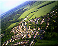
Housing estate and school on southern edge of Bury St Edmunds
This photo, taken from a model aircraft over Hardwick Heath (visible bottom right) primarily shows the part of the Nowton estate nearest to the heath, and beyond that Hardwick Middle School. In the field to the right there is the world's worst crop circle or possibly agricultural operations avoiding a power pole.
The village of Nowton is at the top of the frame.
Image: © John Goldsmith
Taken: 12 Jun 2010
0.25 miles