IMAGES TAKEN NEAR TO
Vinery Road, BURY ST. EDMUNDS, IP33 2JR
Introduction
This page details the photographs taken nearby to Vinery Road, IP33 2JR by members of the Geograph project.
The Geograph project started in 2005 with the aim of publishing, organising and preserving representative images for every square kilometre of Great Britain, Ireland and the Isle of Man.

There are currently over 7.5m images from over14,400 individuals and you can help contribute to the project by visiting https://www.geograph.org.uk
Image Map
Images are licensed for reuse under creativecommons.org/licenses/by-sa/2.0
Notes
- Clicking on the map will re-center to the selected point.
- The higher the marker number, the further away the image location is from the centre of the postcode.
Image Listing (37 Images Found)
Images are licensed for reuse under creativecommons.org/licenses/by-sa/2.0
Image
Details
Distance
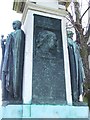
3
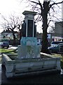
Ouida memorial
Ouida was the pen name of the English novelist Maria Louise Ramé (although she preferred to be known as Marie Louise de la Ramée). The memorial was erected from funds subscribed by readers of the Daily Mirror. For close up views see http://www.geograph.org.uk/photo/655811 , http://www.geograph.org.uk/photo/655819 ,http://www.geograph.org.uk/photo/655822 and for more info on her see http://www.stedmundsbury.gov.uk/sebc/visit/Ouida-Memorial.cfm and http://en.wikipedia.org/wiki/Ouida
Image: © Keith Evans
Taken: 12 Jan 2008
0.04 miles
4
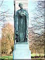
Sympathy
Close up of part of the Ouida memorial Bury St.Edmunds also see http://www.geograph.org.uk/photo/655802 , http://www.stedmundsbury.gov.uk/sebc/visit/Ouida-Memorial.cfm and http://en.wikipedia.org/wiki/Ouida
Image: © Keith Evans
Taken: 12 Jan 2008
0.04 miles
5
Close up of Ouida memorial
Close up of part of the Ouida memorial Bury St.Edmunds also see http://www.geograph.org.uk/photo/655802 , http://www.stedmundsbury.gov.uk/sebc/visit/Ouida-Memorial.cfm and http://en.wikipedia.org/wiki/Ouida
Image: © Keith Evans
Taken: 12 Jan 2008
0.04 miles
6
Courage
Close up of part of the Ouida memorial Bury St.Edmunds also see http://www.geograph.org.uk/photo/655802 , http://www.stedmundsbury.gov.uk/sebc/visit/Ouida-Memorial.cfm and http://en.wikipedia.org/wiki/Ouida
Image: © Keith Evans
Taken: 12 Jan 2008
0.04 miles
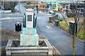
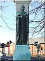
10
![Bury St Edmunds features [45]](https://s1.geograph.org.uk/geophotos/06/70/40/6704041_b176ca21_120x120.jpg)
Bury St Edmunds features [45]
At the junction of Vinery Road and Out Westgate stands this Ouida memorial. Erected in the early 20th century it takes the form of a drinking trough with a rectangular stone column and two bronze figures. Plaques read 'Ouida. Louise De La Ramee'; 'Born at Bury St Edmunds January 1st 1839, died at Vareggio, Italy, January 25th 1908. Her friends have erected this fountain in the place of her birth. Here may God's creatures whom she loved assuage her tender soul as they drink. Curzon of Kedleston.'; 'This memorial was erected from funds subscribed by readers of the Daily Mirror and by friends and admirers in all parts of the world.': Listed, grade II, with details at: https://historicengland.org.uk/listing/the-list/list-entry/1365860
Westgate Street is the southernmost street of the medieval grid and it is mainly about the Greene King Brewery with so many of the buildings constructed for its processes or for its employees. In addition to the brewery there is a rich mix of historic buildings in diverse materials, including white brick, red brick and stucco render. The street has the only surviving intact Regency theatre.
Bury St Edmunds is a market town which is the cultural and retail centre for West Suffolk and is known for brewing (Greene King) and sugar (British Sugar). There is scattered evidence of earlier activity but essentially Bury St Edmunds began as one of the royal boroughs of the Saxons and a monastery was founded which became the burial place of King Edmund. A new Benedictine abbey was built in 1020 which became rich and powerful and the town was laid out on a grid pattern by Abbot Baldwin. After the dissolution the abbey became ruinous. A new church, later the cathedral, was begun in the early 16th century.
Image: © Michael Dibb
Taken: 11 Sep 2020
0.05 miles