IMAGES TAKEN NEAR TO
Raingate Street, BURY ST. EDMUNDS, IP33 2AP
Introduction
This page details the photographs taken nearby to Raingate Street, IP33 2AP by members of the Geograph project.
The Geograph project started in 2005 with the aim of publishing, organising and preserving representative images for every square kilometre of Great Britain, Ireland and the Isle of Man.

There are currently over 7.5m images from over14,400 individuals and you can help contribute to the project by visiting https://www.geograph.org.uk
Image Map
Images are licensed for reuse under creativecommons.org/licenses/by-sa/2.0
Notes
- Clicking on the map will re-center to the selected point.
- The higher the marker number, the further away the image location is from the centre of the postcode.
Image Listing (1051 Images Found)
Images are licensed for reuse under creativecommons.org/licenses/by-sa/2.0
Image
Details
Distance
1
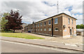
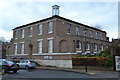
Police Station, Bury St Edmunds
The Police Station of Suffolk Constabulary in Raingate Street.
Image: © David P Howard
Taken: 16 May 2015
0.01 miles
2
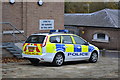
Setting A Good Example
Police car parked outside the police station at Bury St. Edmunds, Suffolk.
Image: © Keith Evans
Taken: 24 Nov 2013
0.02 miles
3
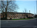
Bury St.Edmunds Police Station
Bury St.Edmunds police station Raingate street Bury St.Edmunds Suffolk.
Image: © Keith Evans
Taken: 1 Jan 2007
0.02 miles
4
![Bury St Edmunds features [13]](https://s2.geograph.org.uk/geophotos/06/68/09/6680998_ade4cf81_120x120.jpg)
Bury St Edmunds features [13]
Seen in Swan Lane is the boundary wall to number 5 St Mary's Square. Built in the late 18th or early 19th century, some 28 yards long (26 metres), in red brick, partly random, with an admixture of flint and stone blocks, irregularly laid, at the base. Listed, grade II, with details at: https://historicengland.org.uk/listing/the-list/list-entry/1135170
Sparhawk Street runs from Honey Hill via the open space of St Mary’s Square to Southgate Street which leads to Southgate Green, the site of the town’s Southgate and where St Petronella’s Hospital was located, established in the 12th century for the treatment of female lepers. The area is rich in history and has a great variety of buildings.
Bury St Edmunds is a market town which is the cultural and retail centre for West Suffolk and is known for brewing (Greene King) and sugar (British Sugar). There is scattered evidence of earlier activity but essentially Bury St Edmunds began as one of the royal boroughs of the Saxons and a monastery was founded which became the burial place of King Edmund. A new Benedictine abbey was built in 1020 which became rich and powerful and the town was laid out on a grid pattern by Abbot Baldwin. After the dissolution the abbey became ruinous. A new church, later the cathedral, was begun in the early 16th century.
Image: © Michael Dibb
Taken: 11 Sep 2020
0.05 miles
5
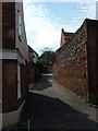
Prussia Lane, Bury St. Edmunds
The map says this is Prussia Lane, but the road itself has no sign, at this end at least. It connects Raingate Street to Southgate Street. Assuming that these road names come from the openings in the original town walls, it is surprising that two were built so close together.
The house with the tall wall is called Red Bricks - good to see that they found such a distinctive feature to inspire the name.
Image: © John Goldsmith
Taken: 3 Sep 2011
0.06 miles
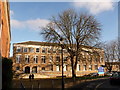
6
The Records Office
Suffolk County Councils records office in Bury St.Edmunds, Suffolk.
Image: © Keith Evans
Taken: 24 Nov 2013
0.06 miles
7
Bury St. Edmunds: Shirehall
A regional headquarters of Suffolk County Council, situated towards the south of the town centre.
Image: © Chris Downer
Taken: 27 Nov 2010
0.06 miles
8
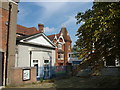
Registry Office, Bury St. Edmunds
The Registry Office displays quite a mixture of architectural styles, including a 1960s raised walkway to the adjoining office block. This was formerly the Suffolk County Council premises, briefly the library while the real one was refurbished, and now lays empty looking for a new tenant.
Image: © John Goldsmith
Taken: 2 Sep 2011
0.06 miles
9
![Bury St Edmunds buildings [162]](https://s3.geograph.org.uk/geophotos/06/67/90/6679007_001bdd9a_120x120.jpg)
Bury St Edmunds buildings [162]
The Suffolk Records Office, 77 Raingate Street, is a library, part of a new complex of county offices with a police station and county offices. Built in 1965 in brown brick with Portland stone dressings and a timber cupola. On local government reorganisation in 1974 it became a branch of the County Record Office. Listed, grade II, with details at: https://historicengland.org.uk/listing/the-list/list-entry/1425808
Sparhawk Street runs from Honey Hill via the open space of St Mary’s Square to Southgate Street which leads to Southgate Green, the site of the town’s Southgate and where St Petronella’s Hospital was located, established in the 12th century for the treatment of female lepers. The area is rich in history and has a great variety of buildings.
Bury St Edmunds is a market town which is the cultural and retail centre for West Suffolk and is known for brewing (Greene King) and sugar (British Sugar). There is scattered evidence of earlier activity but essentially Bury St Edmunds began as one of the royal boroughs of the Saxons and a monastery was founded which became the burial place of King Edmund. A new Benedictine abbey was built in 1020 which became rich and powerful and the town was laid out on a grid pattern by Abbot Baldwin. After the dissolution the abbey became ruinous. A new church, later the cathedral, was begun in the early 16th century.
Image: © Michael Dibb
Taken: 11 Sep 2020
0.06 miles
10
![Bury St Edmunds houses [184]](https://s0.geograph.org.uk/geophotos/06/68/09/6680996_e542d35c_120x120.jpg)
Bury St Edmunds houses [184]
Number 5 (seen here) and number 6 St Mary's Square Image have an early 16th century timber framed house divided between the two properties. In the early 18th century a two bay extension in red brick was constructed on each side of the original house, the top storey was added and the whole refronted. In the early 19th century the house was further extended at the rear and divided into two. Some fine 17th, 18th and 19th century internal features remain. Listed, grade II*, with details at: https://historicengland.org.uk/listing/the-list/list-entry/1135169
Sparhawk Street runs from Honey Hill via the open space of St Mary’s Square to Southgate Street which leads to Southgate Green, the site of the town’s Southgate and where St Petronella’s Hospital was located, established in the 12th century for the treatment of female lepers. The area is rich in history and has a great variety of buildings.
Bury St Edmunds is a market town which is the cultural and retail centre for West Suffolk and is known for brewing (Greene King) and sugar (British Sugar). There is scattered evidence of earlier activity but essentially Bury St Edmunds began as one of the royal boroughs of the Saxons and a monastery was founded which became the burial place of King Edmund. A new Benedictine abbey was built in 1020 which became rich and powerful and the town was laid out on a grid pattern by Abbot Baldwin. After the dissolution the abbey became ruinous. A new church, later the cathedral, was begun in the early 16th century.
Image: © Michael Dibb
Taken: 11 Sep 2020
0.06 miles