IMAGES TAKEN NEAR TO
Northgate Lodge, BURY ST. EDMUNDS, IP33 1UF
Introduction
This page details the photographs taken nearby to Northgate Lodge, IP33 1UF by members of the Geograph project.
The Geograph project started in 2005 with the aim of publishing, organising and preserving representative images for every square kilometre of Great Britain, Ireland and the Isle of Man.

There are currently over 7.5m images from over14,400 individuals and you can help contribute to the project by visiting https://www.geograph.org.uk
Image Map
Images are licensed for reuse under creativecommons.org/licenses/by-sa/2.0
Notes
- Clicking on the map will re-center to the selected point.
- The higher the marker number, the further away the image location is from the centre of the postcode.
Image Listing (397 Images Found)
Images are licensed for reuse under creativecommons.org/licenses/by-sa/2.0
Image
Details
Distance
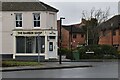
1
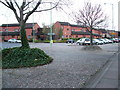
Northgate roundabout
The point where Tayfen Road joins the Northgate Street roundabout.
Image: © John Goldsmith
Taken: 31 Mar 2008
0.01 miles
2
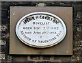
Plaque to Henry Cockton
Henry was born in London but died in Bury St. Edmunds. This plaque is in the road called Long Brackland. His most famous novel was one of the first descriptions of ventriloquism. He is also commemorated on a plaque in the cathedral churchyard, which reveals a discrepancy in his death date - it is reported that several of these house plaques are inaccurate. The Great Churchyard plaque can be seen at Image
Image: © John Goldsmith
Taken: 1 Sep 2008
0.02 miles
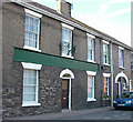
4
![Bury St Edmunds houses [254]](https://s2.geograph.org.uk/geophotos/06/69/08/6690814_fd0ed0e4_120x120.jpg)
Bury St Edmunds houses [254]
Once The Seven Stars public house which closed in 1917 it is now five dwellings, numbers 17, 17A, 18, 18A and 19 Long Brackland. Built in the early 19th century in white brick. The former entrance to the yard has been infilled. There is a shop window on the right. Listed, grade II, with details at: https://historicengland.org.uk/listing/the-list/list-entry/1022589
North of the town centre Northgate Street and St John’s Street run towards the site of Northgate and the railway station and both streets have many older buildings. In between these two streets is a number of streets irregularly laid out (compared to the medieval grid of the town centre) containing mostly houses and buildings from the 19th century.
Bury St Edmunds is a market town which is the cultural and retail centre for West Suffolk and is known for brewing (Greene King) and sugar (British Sugar). There is scattered evidence of earlier activity but essentially Bury St Edmunds began as one of the royal boroughs of the Saxons and a monastery was founded which became the burial place of King Edmund. A new Benedictine abbey was built in 1020 which became rich and powerful and the town was laid out on a grid pattern by Abbot Baldwin. After the dissolution the abbey became ruinous. A new church, later the cathedral, was begun in the early 16th century.
Image: © Michael Dibb
Taken: 7 Sep 2020
0.02 miles
5
Former business frontage in Long Brackland
I am sure the name of the Victorian business that occupied these premises was still present until a few years ago, but now painted out. Some very odd brickwork with lots of half bricks.
This is next door to the plaque Image
Image: © John Goldsmith
Taken: 1 Sep 2008
0.03 miles
7
![Bury St Edmunds houses [253]](https://s1.geograph.org.uk/geophotos/06/69/07/6690789_54bd38c5_120x120.jpg)
Bury St Edmunds houses [253]
Number 16 Long Brackland is early 19th century in white brick. Below the middle window is a stone plaque commemorating the residence of Henry Cockton, novelist, (1807-1853). Listed, grade II, with details at: https://historicengland.org.uk/listing/the-list/list-entry/1022588
North of the town centre Northgate Street and St John’s Street run towards the site of Northgate and the railway station and both streets have many older buildings. In between these two streets is a number of streets irregularly laid out (compared to the medieval grid of the town centre) containing mostly houses and buildings from the 19th century.
Bury St Edmunds is a market town which is the cultural and retail centre for West Suffolk and is known for brewing (Greene King) and sugar (British Sugar). There is scattered evidence of earlier activity but essentially Bury St Edmunds began as one of the royal boroughs of the Saxons and a monastery was founded which became the burial place of King Edmund. A new Benedictine abbey was built in 1020 which became rich and powerful and the town was laid out on a grid pattern by Abbot Baldwin. After the dissolution the abbey became ruinous. A new church, later the cathedral, was begun in the early 16th century.
Image: © Michael Dibb
Taken: 7 Sep 2020
0.03 miles
8
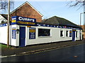
Currys
Currys service centre for shoe repairs key cutting and more Cannon street Bury St.Edmunds Suffolk.
Image: © Keith Evans
Taken: 23 Dec 2007
0.03 miles
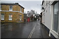
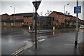
10
Roads into Northgate Street roundabout
Three roads here if you count the one on the right which is now blocked. There are another three into the roundabout behind the photographer.
Image: © John Goldsmith
Taken: 1 Aug 2010
0.04 miles