IMAGES TAKEN NEAR TO
Crown Street, BURY ST. EDMUNDS, IP33 1QX
Introduction
This page details the photographs taken nearby to Crown Street, IP33 1QX by members of the Geograph project.
The Geograph project started in 2005 with the aim of publishing, organising and preserving representative images for every square kilometre of Great Britain, Ireland and the Isle of Man.

There are currently over 7.5m images from over14,400 individuals and you can help contribute to the project by visiting https://www.geograph.org.uk
Image Map
Images are licensed for reuse under creativecommons.org/licenses/by-sa/2.0
Notes
- Clicking on the map will re-center to the selected point.
- The higher the marker number, the further away the image location is from the centre of the postcode.
Image Listing (1863 Images Found)
Images are licensed for reuse under creativecommons.org/licenses/by-sa/2.0
Image
Details
Distance
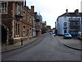
1
![Bury St Edmunds houses [32]](https://s3.geograph.org.uk/geophotos/06/65/42/6654275_4417c270_120x120.jpg)
Bury St Edmunds houses [32]
Number 49 Crown Street is possibly two houses made into one. Built in the 18th century, timber framed and refronted in white brick in the 19th century when the top storey was added. There is an 18th century rear extension. Some original internal features remain. Listed, grade II, with details at: https://historicengland.org.uk/listing/the-list/list-entry/1342763
Crown Street is an historic street that starts with a brewery and finishes with a cathedral, has a medieval graveyard, the second largest parish church in the country and houses from the 16th to the 19th centuries.
Bury St Edmunds is a market town which is the cultural and retail centre for West Suffolk and is known for brewing (Greene King) and sugar (British Sugar). There is scattered evidence of earlier activity but essentially Bury St Edmunds began as one of the royal boroughs of the Saxons and a monastery was founded which became the burial place of King Edmund. A new Benedictine abbey was built in 1020 which became rich and powerful and the town was laid out on a grid pattern by Abbot Baldwin. After the dissolution the abbey became ruinous. A new church, later the cathedral, was begun in the early 16th century.
Image: © Michael Dibb
Taken: 11 Sep 2020
0.00 miles
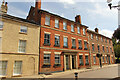
2
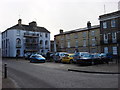
47, 48 and 49 Crown Street, Bury Saint Edmunds
Grade II Listed Houses. 47 is early 18th century re-fronted about 1830. 48 similarly 18th century with mid 19th century front, much modernised in 1970-1. 49 also 18th century with early 19th century roof-raising for the additional top storey. One occupant of 49 was Democratic Party candidate for Bury in 1983 and 1987, Air Marshal Sir Reginald Harland, KBE, CB, MA, CEng, FI Mech E, FIEE, FRAeS, MBIM. (1920-2013) one of the RAF’s most distinguished engineering officers. Among many achievements he was Harrier Project Director at the Ministry of Technology in the late 1960s and saw the jump-jet into service.
Image: © Jo and Steve Turner
Taken: 22 Jun 2017
0.00 miles
3
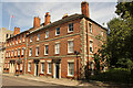
7 & 8 Crown Street
Grade II listed houses 1865-7 on Crown Street
Image: © Richard Croft
Taken: 11 Sep 2023
0.01 miles
4
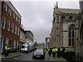
Crown Street closed for John Peel's funeral
A major presence of police and news broadcast vans waits for the famous attendees to leave.
Image: © John Goldsmith
Taken: 12 Nov 2004
0.01 miles
6
![Bury St Edmunds houses [33]](https://s1.geograph.org.uk/geophotos/06/65/42/6654277_fc922e2c_120x120.jpg)
Bury St Edmunds houses [33]
Numbers 7 and 8 Crown Street are a pair of houses built in 1867 in red brick with cement dressings. Listed, for group value, grade II, with details at: https://historicengland.org.uk/listing/the-list/list-entry/1076936
Crown Street is an historic street that starts with a brewery and finishes with a cathedral, has a medieval graveyard, the second largest parish church in the country and houses from the 16th to the 19th centuries.
Bury St Edmunds is a market town which is the cultural and retail centre for West Suffolk and is known for brewing (Greene King) and sugar (British Sugar). There is scattered evidence of earlier activity but essentially Bury St Edmunds began as one of the royal boroughs of the Saxons and a monastery was founded which became the burial place of King Edmund. A new Benedictine abbey was built in 1020 which became rich and powerful and the town was laid out on a grid pattern by Abbot Baldwin. After the dissolution the abbey became ruinous. A new church, later the cathedral, was begun in the early 16th century.
Image: © Michael Dibb
Taken: 11 Sep 2020
0.01 miles
7
![Bury St Edmunds houses [35]](https://s3.geograph.org.uk/geophotos/06/65/42/6654287_582a03e5_120x120.jpg)
Bury St Edmunds houses [35]
Number 5 and 6 Crown Street are a pair of houses built in 1867 in red brick with cement dressings. Listed, for group value, grade II, with details at: https://historicengland.org.uk/listing/the-list/list-entry/1076934
Crown Street is an historic street that starts with a brewery and finishes with a cathedral, has a medieval graveyard, the second largest parish church in the country and houses from the 16th to the 19th centuries.
Bury St Edmunds is a market town which is the cultural and retail centre for West Suffolk and is known for brewing (Greene King) and sugar (British Sugar). There is scattered evidence of earlier activity but essentially Bury St Edmunds began as one of the royal boroughs of the Saxons and a monastery was founded which became the burial place of King Edmund. A new Benedictine abbey was built in 1020 which became rich and powerful and the town was laid out on a grid pattern by Abbot Baldwin. After the dissolution the abbey became ruinous. A new church, later the cathedral, was begun in the early 16th century.
Image: © Michael Dibb
Taken: 11 Sep 2020
0.01 miles
8
![Bury St Edmunds houses [34]](https://s3.geograph.org.uk/geophotos/06/65/42/6654279_2bacf14a_120x120.jpg)
Bury St Edmunds houses [34]
Number 50 Crown Street also has a frontage onto Chequer Square (see Image). Built in 1840 in stuccoed brick with attractive windows with semicircular arched heads with radiating glazing-bars. The frontage to Chequer Square has a first floor cast iron balcony. Listed, grade II, with details at: https://historicengland.org.uk/listing/the-list/list-entry/1342764
Crown Street is an historic street that starts with a brewery and finishes with a cathedral, has a medieval graveyard, the second largest parish church in the country and houses from the 16th to the 19th centuries.
Bury St Edmunds is a market town which is the cultural and retail centre for West Suffolk and is known for brewing (Greene King) and sugar (British Sugar). There is scattered evidence of earlier activity but essentially Bury St Edmunds began as one of the royal boroughs of the Saxons and a monastery was founded which became the burial place of King Edmund. A new Benedictine abbey was built in 1020 which became rich and powerful and the town was laid out on a grid pattern by Abbot Baldwin. After the dissolution the abbey became ruinous. A new church, later the cathedral, was begun in the early 16th century.
Image: © Michael Dibb
Taken: 11 Sep 2020
0.01 miles
9
5 & 6 Crown Street
Grade II listed houses 1865-7 on Crown Street
Image: © Richard Croft
Taken: 11 Sep 2023
0.01 miles