
IMAGES TAKEN NEAR TO
College Lane, BURY ST. EDMUNDS, IP33 1NN
Introduction
This page details the photographs taken nearby to College Lane, IP33 1NN by members of the Geograph project.
The Geograph project started in 2005 with the aim of publishing, organising and preserving representative images for every square kilometre of Great Britain, Ireland and the Isle of Man.

There are currently over 7.5m images from over14,400 individuals and you can help contribute to the project by visiting https://www.geograph.org.uk
Image Map
Images are licensed for reuse under creativecommons.org/licenses/by-sa/2.0
Notes
- Clicking on the map will re-center to the selected point.
- The higher the marker number, the further away the image location is from the centre of the postcode.
Image Listing (1812 Images Found)
Images are licensed for reuse under creativecommons.org/licenses/by-sa/2.0
Image
Details
Distance
1

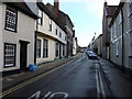
College Lane, Bury St Edmunds (1)
Sneaking between houses on College Street.
Image: © Richard Vince
Taken: 3 Feb 2018
0.00 miles
2
![Bury St Edmunds features [11]](https://s0.geograph.org.uk/geophotos/06/67/69/6676992_7db8c062_120x120.jpg)
Bury St Edmunds features [11]
At the east end of College Lane, near the junction with College Street, these 19th century cast iron bollards prevent cars using the route. Listed, grade II, with details at: https://historicengland.org.uk/listing/the-list/list-entry/1248303
College Lane, also known as Hogg Lane is a pedestrianised east-west route in the medieval grid plan. In two parts, divided by Whiting Street it runs from Guildhall Street to College Street. On the east side of College Road the route continues as Church Walks.
Bury St Edmunds is a market town which is the cultural and retail centre for West Suffolk and is known for brewing (Greene King) and sugar (British Sugar). There is scattered evidence of earlier activity but essentially Bury St Edmunds began as one of the royal boroughs of the Saxons and a monastery was founded which became the burial place of King Edmund. A new Benedictine abbey was built in 1020 which became rich and powerful and the town was laid out on a grid pattern by Abbot Baldwin. After the dissolution the abbey became ruinous. A new church, later the cathedral, was begun in the early 16th century.
Image: © Michael Dibb
Taken: 12 Sep 2020
0.01 miles
3
![Bury St Edmunds houses [151]](https://s3.geograph.org.uk/geophotos/06/67/60/6676011_bd3dc131_120x120.jpg)
Bury St Edmunds houses [151]
Number 50 College Street, The Old Beehive, was built as a house, later a public house, later a school and now a house again. Built in the 16th century, timber framed, with alterations and a refronting in brick in the early 19th century. The rear wall is in kidney flint with red brick dressings. There are two ranges at the rear, one probably 16th century one early 19th century. Above the doorway can be seen the blocked elliptical arch of a former wide carriage entry. The licence for the public house was transferred to number 21 College Street Image in 1858. Listed, grade II, with details at: https://historicengland.org.uk/listing/the-list/list-entry/1076951
Image: © Michael Dibb
Taken: 12 Sep 2020
0.01 miles
4
![Bury St Edmunds houses [152]](https://s2.geograph.org.uk/geophotos/06/67/60/6676022_4322db29_120x120.jpg)
Bury St Edmunds houses [152]
A mid 16th century hall house has been divided into three - numbers 51 and 52 College Street and number 7 College Lane. Timber framed and originally jettied on two sides, the house was extended in the 17th century and remodelled and refronted in white brick in the early 19th century. Listed, grade II, with details at: https://historicengland.org.uk/listing/the-list/list-entry/1076952
College Street is one of the north-south streets within the medieval grid and is a continuation southward of Hatter Street, running from Churchgate Street to Westgate Street. Almost entirely residential but there is a Victorian school at the south end.
Bury St Edmunds is a market town which is the cultural and retail centre for West Suffolk and is known for brewing (Greene King) and sugar (British Sugar). There is scattered evidence of earlier activity but essentially Bury St Edmunds began as one of the royal boroughs of the Saxons and a monastery was founded which became the burial place of King Edmund. A new Benedictine abbey was built in 1020 which became rich and powerful and the town was laid out on a grid pattern by Abbot Baldwin. After the dissolution the abbey became ruinous. A new church, later the cathedral, was begun in the early 16th century.
Image: © Michael Dibb
Taken: 12 Sep 2020
0.01 miles
5
![Bury St Edmunds houses [154]](https://s2.geograph.org.uk/geophotos/06/67/69/6676990_eb66e76c_120x120.jpg)
Bury St Edmunds houses [154]
Now a house and separate flat, numbers 7A and 8 College Lane were built in the 16th century, timber framed and roughcast. Altered in the 19th century when a rear addition was constructed and the top storey was added. Listed, grade II, with details at: https://historicengland.org.uk/listing/the-list/list-entry/1248302
College Lane, also known as Hogg Lane is a pedestrianised east-west route in the medieval grid plan. In two parts, divided by Whiting Street it runs from Guildhall Street to College Street. On the east side of College Road the route continues as Church Walks.
Bury St Edmunds is a market town which is the cultural and retail centre for West Suffolk and is known for brewing (Greene King) and sugar (British Sugar). There is scattered evidence of earlier activity but essentially Bury St Edmunds began as one of the royal boroughs of the Saxons and a monastery was founded which became the burial place of King Edmund. A new Benedictine abbey was built in 1020 which became rich and powerful and the town was laid out on a grid pattern by Abbot Baldwin. After the dissolution the abbey became ruinous. A new church, later the cathedral, was begun in the early 16th century.
Image: © Michael Dibb
Taken: 12 Sep 2020
0.01 miles
7
![Bury St Edmunds houses [150]](https://s0.geograph.org.uk/geophotos/06/67/59/6675936_cf4808d2_120x120.jpg)
Bury St Edmunds houses [150]
Number 49 College Street is 17th century, timber framed and stuccoed. The house was refronted in the early 19th century and the roof was probably raised at the same time. Listed, grade II, with details at: https://historicengland.org.uk/listing/the-list/list-entry/1076950
College Street is one of the north-south streets within the medieval grid and is a continuation southward of Hatter Street, running from Churchgate Street to Westgate Street. Almost entirely residential but there is a Victorian school at the south end.
Bury St Edmunds is a market town which is the cultural and retail centre for West Suffolk and is known for brewing (Greene King) and sugar (British Sugar). There is scattered evidence of earlier activity but essentially Bury St Edmunds began as one of the royal boroughs of the Saxons and a monastery was founded which became the burial place of King Edmund. A new Benedictine abbey was built in 1020 which became rich and powerful and the town was laid out on a grid pattern by Abbot Baldwin. After the dissolution the abbey became ruinous. A new church, later the cathedral, was begun in the early 16th century.
Image: © Michael Dibb
Taken: 12 Sep 2020
0.01 miles
8
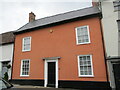
49 College Street, Bury St Edmunds
Refronted seventeenth century house https://historicengland.org.uk/listing/the-list/list-entry/1076950?section=official-list-entry
Image: © Jonathan Thacker
Taken: 16 May 2022
0.02 miles
9
![Bury St Edmunds houses [149]](https://s3.geograph.org.uk/geophotos/06/67/59/6675931_0fe7adb5_120x120.jpg)
Bury St Edmunds houses [149]
Number 48 College Street is 17th century, timber framed and roughcast, refronted in the 19th century. There is a later rear wing. Listed, grade II, with details at: https://historicengland.org.uk/listing/the-list/list-entry/1076949
College Street is one of the north-south streets within the medieval grid and is a continuation southward of Hatter Street, running from Churchgate Street to Westgate Street. Almost entirely residential but there is a Victorian school at the south end.
Bury St Edmunds is a market town which is the cultural and retail centre for West Suffolk and is known for brewing (Greene King) and sugar (British Sugar). There is scattered evidence of earlier activity but essentially Bury St Edmunds began as one of the royal boroughs of the Saxons and a monastery was founded which became the burial place of King Edmund. A new Benedictine abbey was built in 1020 which became rich and powerful and the town was laid out on a grid pattern by Abbot Baldwin. After the dissolution the abbey became ruinous. A new church, later the cathedral, was begun in the early 16th century.
Image: © Michael Dibb
Taken: 12 Sep 2020
0.02 miles
10
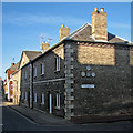
Bury St Edmunds: the former William Barnaby Almshouses
The almshouses were endowed in 1571 and rebuilt in 1826. Now four houses, from 1954-78 the building was occupied by a builders' merchant, whose faded painted lettering still appears on the frontage: Timber Merchants Marlow & Co Ltd Builders Supplies. For closer views of this lettering, see Image] and Image
For the British Listed Buildings citation, see http://www.britishlistedbuildings.co.uk/en-466736-8-11-college-street-b.ury-st-edmunds-suff .
Image: © John Sutton
Taken: 17 Feb 2015
0.02 miles