IMAGES TAKEN NEAR TO
Angel Hill, BURY ST. EDMUNDS, IP33 1LS
Introduction
This page details the photographs taken nearby to Angel Hill, IP33 1LS by members of the Geograph project.
The Geograph project started in 2005 with the aim of publishing, organising and preserving representative images for every square kilometre of Great Britain, Ireland and the Isle of Man.

There are currently over 7.5m images from over14,400 individuals and you can help contribute to the project by visiting https://www.geograph.org.uk
Image Map
Images are licensed for reuse under creativecommons.org/licenses/by-sa/2.0
Notes
- Clicking on the map will re-center to the selected point.
- The higher the marker number, the further away the image location is from the centre of the postcode.
Image Listing (1987 Images Found)
Images are licensed for reuse under creativecommons.org/licenses/by-sa/2.0
Image
Details
Distance
2
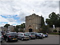
Bury St Edmunds: Angel Hill
Looking past the Cathedral Shop towards the Abbey Gateway on a sunny January morning.
Image: © John Sutton
Taken: 23 Jan 2015
0.01 miles
3
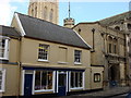
![Bury St Edmunds buildings [49]](https://s2.geograph.org.uk/geophotos/06/64/96/6649674_0ff0f9c1_120x120.jpg)
Bury St Edmunds buildings [49]
Built up against a section of the precinct wall of the former abbey, Abbey House, number 30 Angel Hill, has a late 16th century timber framed core to part, an 18th and 19th century front to Angel Hill with an 18th century rear facing Abbey Gardens. Built circa 1720 the house is now the cathedral office. Listed, grade II*, with details at: https://historicengland.org.uk/listing/the-list/list-entry/1141178 Now used as a car park, Angel Hill the traditional market place was, until the 1870s, home to the famous Bury Fair. People from Europe and across the Far East came to buy and sell.
Bury St Edmunds is a market town which is the cultural and retail centre for West Suffolk and is known for brewing (Greene King) and sugar (British Sugar). There is scattered evidence of earlier activity but essentially Bury St Edmunds began as one of the royal boroughs of the Saxons and a monastery was founded which became the burial place of King Edmund. A new Benedictine abbey was built in 1020 which became rich and powerful and the town was laid out on a grid pattern by Abbot Baldwin. After the dissolution the abbey became ruinous. A new church, later the cathedral, was begun in the early 16th century.
Image: © Michael Dibb
Taken: 11 Sep 2020
0.01 miles
4
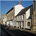
Bury St Edmunds on a winter afternoon
Looking towards the Cathedral from the corner of Abbeygate Street on a bright February afternoon,
Image: © John Sutton
Taken: 17 Feb 2015
0.02 miles
5
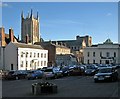
![Bury St Edmunds buildings [51]](https://s2.geograph.org.uk/geophotos/06/65/09/6650906_c003e421_120x120.jpg)
Bury St Edmunds buildings [51]
The block of 3 storey buildings, numbers 31, 32 and 33 Angel Hill were three separate early to mid 19th century houses with shops in white brick, now combined into one property. The rear of the building incorporates a section of the precinct wall of the former abbey of St Edmund which rises to the level of the 2nd storey. In recent years the ground floor has been a restaurant, the cathedral discovery centre and an art gallery. Listed, grade II*, with details at: https://historicengland.org.uk/listing/the-list/list-entry/1141179
The two storey property beyond, number 34 Angel Hill, was a house and shop now a shop with offices above. The building has a timber framed 16th century core which was refronted in brick in the early 19th century. The shop front is late 20th century and is currently the cathedral shop. Listed, grade II, with details at: https://historicengland.org.uk/listing/the-list/list-entry/1376998
Now used as a car park, Angel Hill the traditional market place was, until the 1870s, home to the famous Bury Fair. People from Europe and across the Far East came to buy and sell.
Bury St Edmunds is a market town which is the cultural and retail centre for West Suffolk and is known for brewing (Greene King) and sugar (British Sugar). There is scattered evidence of earlier activity but essentially Bury St Edmunds began as one of the royal boroughs of the Saxons and a monastery was founded which became the burial place of King Edmund. A new Benedictine abbey was built in 1020 which became rich and powerful and the town was laid out on a grid pattern by Abbot Baldwin. After the dissolution the abbey became ruinous. A new church, later the cathedral, was begun in the early 16th century.
Image: © Michael Dibb
Taken: 11 Sep 2020
0.02 miles
6
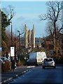
Distant view
Looking east along Robert Boby Way Bury St.Edmunds with the new tower of St.Edmundsbury Cathedral
Image: © Keith Evans
Taken: 3 Dec 2006
0.02 miles
7
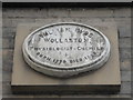
Commemorative plaque in Angel Hill (A)
Also see https://en.wikipedia.org/wiki/William_Hyde_Wollaston
Image: © Basher Eyre
Taken: 31 Jul 2016
0.02 miles
8
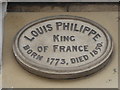
Commemorative plaque in Angel Hill (B)
Also see https://en.wikipedia.org/wiki/Louis_Philippe_I
Image: © Basher Eyre
Taken: 31 Jul 2016
0.02 miles
9
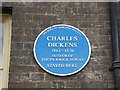
Commemorative plaque in Angel Hill (C)
Also see https://en.wikipedia.org/wiki/Charles_Dickens
Image: © Basher Eyre
Taken: 31 Jul 2016
0.02 miles